Megina geodata
Megina (Castille-La Mancha) is a seat of a third-order administrative division; located in Spain in Europe/Madrid (GMT+2) time zone. With population of 54 people, there are 6416 cities with bigger population in this country. Compared to other cities in Spain, 59% of cities are located further ↑North; 68.8% of cities are located further ←West and 98% of cities have lower elevation than Megina. Note1
Administrative division(s):
- Level 1: Castille-La Mancha
- Level 2: Provincia de Guadalajara
- Level 3: Megina


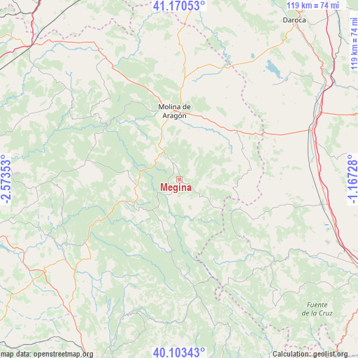
Megina GPS coordinates[2]
40° 38' 20.796" North, 1° 52' 13.476" West
| Map corner | latitude | longitude |
|---|---|---|
| Upper-left | 41.17053°, | -2.57353° |
| Center: | 40.63911°, | -1.87041° |
| Lower-right: | 40.10343°, | -1.16728° |
| Map W x H: | 118.7×118.6 km | = 73.8×73.7mi |
| max Lat: | 43.74134° ⇑59% North |
| Megina: | 40.63911° |
| min Lat: | ⇓41% South 27.64134° |
| min Long | Megina | max Long |
| -18.00367° | -1.87041° | 4.2899° |
| W 68.8%⇐ | ⇒31.2% E |
Elevation
Elevation of Megina is 1253 m = 4111 ft, and this is 655 m = 2149 ft above average elevation for this country.
| Max E: |
1682 m = 5518 ft | 2% |
| Megina | 1253 m 4111 ft | |
| Avg. | 598 m = 1962 ft | |
Min E: |
0 m = 0 ft | 98% |
See also: Spain elevation on elevation.city.
Geographical zone
Megina is located in North temperate zone (between Tropic of Cancer and the Arctic Circle). Distance of this Northern Tropic circle is 1912.7 km =1188.5 mi to South.| Distance of | km | miles | from Megina |
|---|---|---|---|
| North Pole | 5488.4 | 3410.3 | to North |
| Arctic Circle | 2882.5 | 1791.1 | to North |
| Tropic Cancer | 1912.7 | 1188.5 | to South |
| Equator | 4518.6 | 2807.7 | to South |


Nearby cities:
15 places around Megina: (largest is in red/bold)
• Alcoroches
10.6 km =6.6 mi,  97°
97°
• Baños de Tajo
11.8 km =7.3 mi,  316°
316°
• Checa
9 km =5.6 mi,  131°
131°
• Chequilla
5.1 km =3.2 mi,  135°
135°
• Cueva del Hierro
15.3 km =9.5 mi,  245°
245°
• Orea
15.1 km =9.4 mi, 127°
• Peralejos de las Truchas
6.1 km =3.8 mi,  212°
212°
• Pinilla de Molina
4.6 km =2.9 mi,  349°
349°
• Piqueras
12.8 km =8 mi,  77°
77°
• Poveda de la Sierra
13.4 km =8.3 mi,  271°
271°
• Taravilla
10.5 km =6.5 mi,  308°
308°
• Terzaga
6.8 km =4.2 mi,  335°
335°
• Tierzo
13.3 km =8.3 mi, 337°
• Torrecuadrada de Molina
13.4 km =8.3 mi,  23°
23°
• Torremochuela
14.2 km =8.8 mi,  9°
9°
Sources, notices
• [Note1] Compared only with cities in Spain existing in our database
• [Src1] Map data: © OpenStreetMap contributors (CC-BY-SA)
• [Src2] Other city data from geonames.org with taken over terms of usage.
• [Src3] Geographical zone / Annual Mean Temperature by Robert A. Rohde @ Wikipedia
