Alfajarín geodata
Alfajarín (Aragon) is a seat of a third-order administrative division; located in Spain in Europe/Madrid (GMT+2) time zone. With population of 1,855 people, there are 2255 cities with bigger population in this country. Compared to other cities in Spain, 63.8% of cities are located further ↓South; 79.8% of cities are located further ←West and 81.8% of cities have higher elevation than Alfajarín. Note1


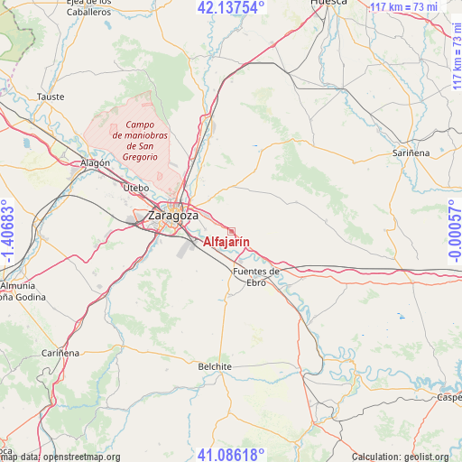
Alfajarín GPS coordinates[2]
41° 36' 50.4" North, 0° 42' 13.32" West
| Map corner | latitude | longitude |
|---|---|---|
| Upper-left | 42.13754°, | -1.40683° |
| Center: | 41.614°, | -0.7037° |
| Lower-right: | 41.08618°, | -0.00057° |
| Map W x H: | 116.9×116.9 km | = 72.6×72.6mi |
| max Lat: | 43.74134° ⇑36.2% North |
| Alfajarín: | 41.614° |
| min Lat: | ⇓63.8% South 27.64134° |
| min Long | Alfajarín | max Long |
| -18.00367° | -0.7037° | 4.2899° |
| W 79.8%⇐ | ⇒20.2% E |
Elevation
Elevation of Alfajarín is 191 m = 627 ft, and this is 407 m = 1335 ft below average elevation for this country.
| Max E: |
1682 m = 5518 ft | 81.8% |
| Avg. | 598 m = 1962 ft | |
| Alfajarín | 191 m = 627 ft | |
Min E: |
0 m = 0 ft | 18.2% |
See also: Spain elevation on elevation.city.
Geographical zone
Alfajarín is located in North temperate zone (between Tropic of Cancer and the Arctic Circle). Distance of this Northern Tropic circle is 2021.1 km =1255.9 mi to South.| Distance of | km | miles | from Alfajarín |
|---|---|---|---|
| North Pole | 5380 | 3343 | to North |
| Arctic Circle | 2774.1 | 1723.7 | to North |
| Tropic Cancer | 2021.1 | 1255.9 | to South |
| Equator | 4627 | 2875.1 | to South |


Nearby cities:
15 places around Alfajarín: (largest is in red/bold)
• Almozara
17.3 km =10.7 mi,  287°
287°
• Cuarte de Huerva
19.2 km =11.9 mi,  263°
263°
• Delicias
17.4 km =10.8 mi,  283°
283°
• El Burgo de Ebro
5.7 km =3.5 mi,  213°
213°
• Farlete
18 km =11.2 mi,  65°
65°
• Fuentes de Ebro
12.8 km =8 mi,  152°
152°
• Mediana
16.4 km =10.2 mi,  180°
180°
• Montecanal
19.6 km =12.2 mi, 275°
• Nuez de Ebro
4 km =2.5 mi,  132°
132°
• Oliver-Valdefierro
19.4 km =12.1 mi, 280°
• Perdiguera
16.7 km =10.4 mi,  20°
20°
• Puebla de Alfindén
4.4 km =2.7 mi,  296°
296°
• Villafranca de Ebro
6.2 km =3.9 mi, 134°
• Villamayor de Gállego
9.8 km =6.1 mi,  324°
324°
• Zaragoza
15.2 km =9.4 mi, 287°
Sources, notices
• [Note1] Compared only with cities in Spain existing in our database
• [Src1] Map data: © OpenStreetMap contributors (CC-BY-SA)
• [Src2] Other city data from geonames.org with taken over terms of usage.
• [Src3] Geographical zone / Annual Mean Temperature by Robert A. Rohde @ Wikipedia
