Farlete geodata
Farlete (Aragon) is a seat of a third-order administrative division; located in Spain in Europe/Madrid (GMT+2) time zone. With population of 436 people, there are 4037 cities with bigger population in this country. Compared to other cities in Spain, 65.6% of cities are located further ↓South; 81.6% of cities are located further ←West and 68.4% of cities have higher elevation than Farlete. Note1


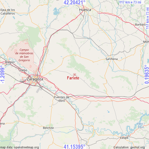
Farlete GPS coordinates[2]
41° 40' 52.392" North, 0° 30' 24.408" West
| Map corner | latitude | longitude |
|---|---|---|
| Upper-left | 42.20421°, | -1.2099° |
| Center: | 41.68122°, | -0.50678° |
| Lower-right: | 41.15395°, | 0.19635° |
| Map W x H: | 116.8×116.8 km | = 72.6×72.6mi |
| max Lat: | 43.74134° ⇑34.4% North |
| Farlete: | 41.68122° |
| min Lat: | ⇓65.6% South 27.64134° |
| min Long | Farlete | max Long |
| -18.00367° | -0.50678° | 4.2899° |
| W 81.6%⇐ | ⇒18.4% E |
Elevation
Elevation of Farlete is 410 m = 1345 ft, and this is 188 m = 617 ft below average elevation for this country.
| Max E: |
1682 m = 5518 ft | 68.4% |
| Avg. | 598 m = 1962 ft | |
| Farlete | 410 m = 1345 ft | |
Min E: |
0 m = 0 ft | 31.6% |
See also: Spain elevation on elevation.city.
Geographical zone
Farlete is located in North temperate zone (between Tropic of Cancer and the Arctic Circle). Distance of this Northern Tropic circle is 2028.6 km =1260.5 mi to South.| Distance of | km | miles | from Farlete |
|---|---|---|---|
| North Pole | 5372.5 | 3338.3 | to North |
| Arctic Circle | 2766.7 | 1719.1 | to North |
| Tropic Cancer | 2028.6 | 1260.5 | to South |
| Equator | 4634.5 | 2879.7 | to South |


Nearby cities:
15 places around Farlete: (largest is in red/bold)
• Alcubierre
14.7 km =9.1 mi,  17°
17°
• Alfajarín
18 km =11.2 mi,  245°
245°
• Castejón de Monegros
23.2 km =14.4 mi,  107°
107°
• El Burgo de Ebro
23 km =14.3 mi,  237°
237°
• Fuentes de Ebro
21.4 km =13.3 mi,  208°
208°
• Lanaja
17.7 km =11 mi,  55°
55°
• Leciñena
15.7 km =9.8 mi,  326°
326°
• Monegrillo
8.9 km =5.5 mi,  122°
122°
• Nuez de Ebro
16.8 km =10.4 mi,  232°
232°
• Perdiguera
13.2 km =8.2 mi,  308°
308°
• Pina de Ebro
21.5 km =13.4 mi,  185°
185°
• Puebla de Alfindén
21.1 km =13.1 mi, 254°
• Robres
21.1 km =13.1 mi,  10°
10°
• Villafranca de Ebro
16.8 km =10.4 mi, 225°
• Villamayor de Gállego
22.1 km =13.7 mi,  271°
271°
Sources, notices
• [Note1] Compared only with cities in Spain existing in our database
• [Src1] Map data: © OpenStreetMap contributors (CC-BY-SA)
• [Src2] Other city data from geonames.org with taken over terms of usage.
• [Src3] Geographical zone / Annual Mean Temperature by Robert A. Rohde @ Wikipedia
