Piloña geodata
Piloña (Asturias) is a seat of a third-order administrative division; located in Spain in Europe/Madrid (GMT+2) time zone. With population of 8,389 people, there are 915 cities with bigger population in this country. Compared to other cities in Spain, 98.2% of cities are located further ↓South; 77.1% of cities are located further →East and 83% of cities have higher elevation than Piloña. Note1


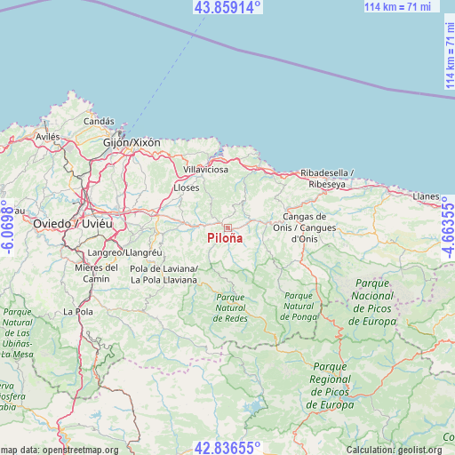
Piloña GPS coordinates[2]
43° 21' 0" North, 5° 22' 0.012" West
| Map corner | latitude | longitude |
|---|---|---|
| Upper-left | 43.85914°, | -6.0698° |
| Center: | 43.35°, | -5.36667° |
| Lower-right: | 42.83655°, | -4.66355° |
| Map W x H: | 113.7×113.7 km | = 70.6×70.6mi |
| max Lat: | 43.74134° ⇑1.8% North |
| Piloña: | 43.35° |
| min Lat: | ⇓98.2% South 27.64134° |
| min Long | Piloña | max Long |
| -18.00367° | -5.36667° | 4.2899° |
| W 22.9%⇐ | ⇒77.1% E |
Elevation
Elevation of Piloña is 168 m = 551 ft, and this is 430 m = 1411 ft below average elevation for this country.
| Max E: |
1682 m = 5518 ft | 83% |
| Avg. | 598 m = 1962 ft | |
| Piloña | 168 m = 551 ft | |
Min E: |
0 m = 0 ft | 17% |
See also: Spain elevation on elevation.city.
Geographical zone
Piloña is located in North temperate zone (between Tropic of Cancer and the Arctic Circle). Distance of this Northern Tropic circle is 2214.1 km =1375.8 mi to South.| Distance of | km | miles | from Piloña |
|---|---|---|---|
| North Pole | 5187 | 3223.1 | to North |
| Arctic Circle | 2581.1 | 1603.8 | to North |
| Tropic Cancer | 2214.1 | 1375.8 | to South |
| Equator | 4820.1 | 2995.1 | to South |


Nearby cities:
15 places around Piloña: (largest is in red/bold)
• Amieva
26.4 km =16.4 mi,  116°
116°
• Arriba
22.9 km =14.2 mi,  323°
323°
• Bimenes
15.3 km =9.5 mi,  255°
255°
• Campo de Caso
18.6 km =11.6 mi,  174°
174°
• Cangas de Onís
19.2 km =11.9 mi,  89°
89°
• Caravia
18.7 km =11.6 mi,  48°
48°
• Colunga
16.9 km =10.5 mi,  27°
27°
• El entrego
23 km =14.3 mi,  252°
252°
• Nava
11.7 km =7.3 mi,  274°
274°
• Parres
17.5 km =10.9 mi, 90°
• Pola de Laviana
19.7 km =12.2 mi,  233°
233°
• Pola de Siero
24.4 km =15.2 mi,  281°
281°
• Santa Eulalia
8.2 km =5.1 mi,  333°
333°
• Sariego
14.6 km =9.1 mi,  292°
292°
• Villaviciosa
15.6 km =9.7 mi,  339°
339°
Sources, notices
• [Note1] Compared only with cities in Spain existing in our database
• [Src1] Map data: © OpenStreetMap contributors (CC-BY-SA)
• [Src2] Other city data from geonames.org with taken over terms of usage.
• [Src3] Geographical zone / Annual Mean Temperature by Robert A. Rohde @ Wikipedia
