Arriba geodata
Arriba (Asturias) is a populated place; located in Spain in Europe/Madrid (GMT+2) time zone. With population of 2,030 people, there are 2146 cities with bigger population in this country. Compared to other cities in Spain, 99.5% of cities are located further ↓South; 79.1% of cities are located further →East and 84.4% of cities have higher elevation than Arriba. Note1


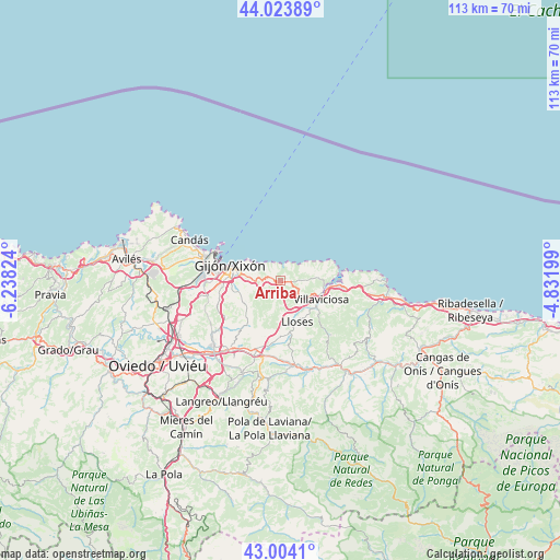
Arriba GPS coordinates[2]
43° 30' 58.14" North, 5° 32' 6.396" West
| Map corner | latitude | longitude |
|---|---|---|
| Upper-left | 44.02389°, | -6.23824° |
| Center: | 43.51615°, | -5.53511° |
| Lower-right: | 43.0041°, | -4.83199° |
| Map W x H: | 113.4×113.4 km | = 70.5×70.5mi |
| max Lat: | 43.74134° ⇑0.5% North |
| Arriba: | 43.51615° |
| min Lat: | ⇓99.5% South 27.64134° |
| min Long | Arriba | max Long |
| -18.00367° | -5.53511° | 4.2899° |
| W 20.9%⇐ | ⇒79.1% E |
Elevation
Elevation of Arriba is 150 m = 492 ft, and this is 448 m = 1470 ft below average elevation for this country.
| Max E: |
1682 m = 5518 ft | 84.4% |
| Avg. | 598 m = 1962 ft | |
| Arriba | 150 m = 492 ft | |
Min E: |
0 m = 0 ft | 15.6% |
See also: Spain elevation on elevation.city.
Geographical zone
Arriba is located in North temperate zone (between Tropic of Cancer and the Arctic Circle). Distance of this Northern Tropic circle is 2232.6 km =1387.3 mi to South.| Distance of | km | miles | from Arriba |
|---|---|---|---|
| North Pole | 5168.5 | 3211.6 | to North |
| Arctic Circle | 2562.6 | 1592.3 | to North |
| Tropic Cancer | 2232.6 | 1387.3 | to South |
| Equator | 4838.5 | 3006.5 | to South |


Nearby cities:
15 places around Arriba: (largest is in red/bold)
• Bimenes
22.2 km =13.8 mi,  183°
183°
• Colunga
21.6 km =13.4 mi,  99°
99°
• El entrego
26.7 km =16.6 mi,  198°
198°
• Gijón
10.4 km =6.5 mi,  282°
282°
• Luanco
23.5 km =14.6 mi,  297°
297°
• Lugones
25.7 km =16 mi,  240°
240°
• Natahoyo
12.2 km =7.6 mi, 282°
• Nava
17.7 km =11 mi,  173°
173°
• Noreña
19.4 km =12.1 mi,  225°
225°
• Piloña
22.9 km =14.2 mi,  143°
143°
• Pola de Siero
17.2 km =10.7 mi,  216°
216°
• Sama
27.3 km =17 mi,  206°
206°
• Santa Eulalia
14.9 km =9.3 mi, 138°
• Sariego
12.9 km =8 mi, 179°
• Villaviciosa
8.9 km =5.5 mi,  115°
115°
Sources, notices
• [Note1] Compared only with cities in Spain existing in our database
• [Src1] Map data: © OpenStreetMap contributors (CC-BY-SA)
• [Src2] Other city data from geonames.org with taken over terms of usage.
• [Src3] Geographical zone / Annual Mean Temperature by Robert A. Rohde @ Wikipedia
