Villaviciosa geodata
Villaviciosa (Asturias) is a seat of a third-order administrative division; located in Spain in Europe/Madrid (GMT+2) time zone. With population of 14,775 people, there are 628 cities with bigger population in this country. Compared to other cities in Spain, 99.4% of cities are located further ↓South; 77.8% of cities are located further →East and 99.5% of cities have higher elevation than Villaviciosa. Note1


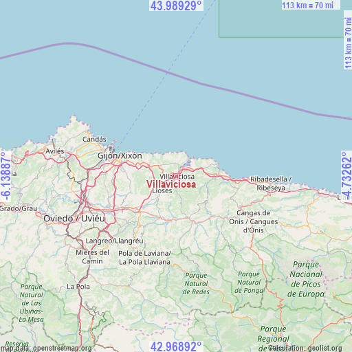
Villaviciosa GPS coordinates[2]
43° 28' 52.536" North, 5° 26' 8.664" West
| Map corner | latitude | longitude |
|---|---|---|
| Upper-left | 43.98929°, | -6.13887° |
| Center: | 43.48126°, | -5.43574° |
| Lower-right: | 42.96892°, | -4.73262° |
| Map W x H: | 113.5×113.5 km | = 70.5×70.5mi |
| max Lat: | 43.74134° ⇑0.6% North |
| Villaviciosa: | 43.48126° |
| min Lat: | ⇓99.4% South 27.64134° |
| min Long | Villaviciosa | max Long |
| -18.00367° | -5.43574° | 4.2899° |
| W 22.2%⇐ | ⇒77.8% E |
Elevation
Elevation of Villaviciosa is 6 m = 20 ft, and this is 592 m = 1942 ft below average elevation for this country.
| Max E: |
1682 m = 5518 ft | 99.5% |
| Avg. | 598 m = 1962 ft | |
| Villaviciosa | 6 m = 20 ft | |
Min E: |
0 m = 0 ft | 0.5% |
See also: Spain elevation on elevation.city.
Geographical zone
Villaviciosa is located in North temperate zone (between Tropic of Cancer and the Arctic Circle). Distance of this Northern Tropic circle is 2228.7 km =1384.8 mi to South.| Distance of | km | miles | from Villaviciosa |
|---|---|---|---|
| North Pole | 5172.4 | 3214 | to North |
| Arctic Circle | 2566.5 | 1594.7 | to North |
| Tropic Cancer | 2228.7 | 1384.8 | to South |
| Equator | 4834.7 | 3004.1 | to South |


Nearby cities:
15 places around Villaviciosa: (largest is in red/bold)
• Arriba
8.9 km =5.5 mi,  295°
295°
• Bimenes
20.5 km =12.7 mi,  206°
206°
• Caravia
19.8 km =12.3 mi,  96°
96°
• Colunga
13.4 km =8.3 mi,  88°
88°
• El entrego
27 km =16.8 mi,  217°
217°
• Gijón
19.2 km =11.9 mi,  288°
288°
• Natahoyo
20.9 km =13 mi, 288°
• Nava
15 km =9.3 mi,  203°
203°
• Noreña
23.9 km =14.9 mi,  245°
245°
• Parres
27.3 km =17 mi,  122°
122°
• Piloña
15.6 km =9.7 mi,  159°
159°
• Pola de Laviana
28.2 km =17.5 mi, 201°
• Pola de Siero
20.9 km =13 mi,  241°
241°
• Santa Eulalia
7.5 km =4.7 mi, 164°
• Sariego
12 km =7.5 mi, 221°
Sources, notices
• [Note1] Compared only with cities in Spain existing in our database
• [Src1] Map data: © OpenStreetMap contributors (CC-BY-SA)
• [Src2] Other city data from geonames.org with taken over terms of usage.
• [Src3] Geographical zone / Annual Mean Temperature by Robert A. Rohde @ Wikipedia
