Sariego geodata
Sariego (Asturias) is a populated place; located in Spain in Europe/Madrid (GMT+2) time zone. With population of 1,367 people, there are 2577 cities with bigger population in this country. Compared to other cities in Spain, 98.8% of cities are located further ↓South; 79.1% of cities are located further →East and 74.5% of cities have higher elevation than Sariego. Note1


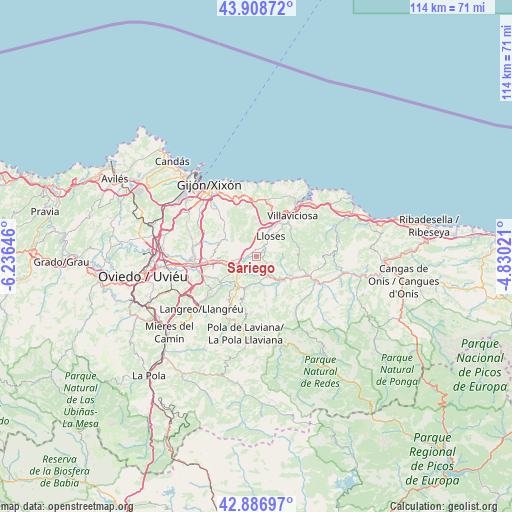
Sariego GPS coordinates[2]
43° 24' 0" North, 5° 31' 59.988" West
| Map corner | latitude | longitude |
|---|---|---|
| Upper-left | 43.90872°, | -6.23646° |
| Center: | 43.4°, | -5.53333° |
| Lower-right: | 42.88697°, | -4.83021° |
| Map W x H: | 113.6×113.6 km | = 70.6×70.6mi |
| max Lat: | 43.74134° ⇑1.2% North |
| Sariego: | 43.4° |
| min Lat: | ⇓98.8% South 27.64134° |
| min Long | Sariego | max Long |
| -18.00367° | -5.53333° | 4.2899° |
| W 20.9%⇐ | ⇒79.1% E |
Elevation
Elevation of Sariego is 304 m = 997 ft, and this is 294 m = 965 ft below average elevation for this country.
| Max E: |
1682 m = 5518 ft | 74.5% |
| Avg. | 598 m = 1962 ft | |
| Sariego | 304 m = 997 ft | |
Min E: |
0 m = 0 ft | 25.5% |
See also: Spain elevation on elevation.city.
Geographical zone
Sariego is located in North temperate zone (between Tropic of Cancer and the Arctic Circle). Distance of this Northern Tropic circle is 2219.7 km =1379.3 mi to South.| Distance of | km | miles | from Sariego |
|---|---|---|---|
| North Pole | 5181.4 | 3219.6 | to North |
| Arctic Circle | 2575.5 | 1600.3 | to North |
| Tropic Cancer | 2219.7 | 1379.3 | to South |
| Equator | 4825.6 | 2998.5 | to South |


Nearby cities:
15 places around Sariego: (largest is in red/bold)
• Arriba
12.9 km =8 mi,  359°
359°
• Bimenes
9.4 km =5.8 mi,  188°
188°
• Colunga
23.3 km =14.5 mi,  65°
65°
• El entrego
15.1 km =9.4 mi,  214°
214°
• Gijón
18.3 km =11.4 mi,  325°
325°
• Lugones
22.5 km =14 mi,  270°
270°
• Natahoyo
19.7 km =12.2 mi,  322°
322°
• Nava
5 km =3.1 mi,  158°
158°
• Noreña
14 km =8.7 mi, 267°
• Piloña
14.6 km =9.1 mi,  112°
112°
• Pola de Laviana
17.4 km =10.8 mi, 187°
• Pola de Siero
10.5 km =6.5 mi, 265°
• Sama
16.8 km =10.4 mi,  226°
226°
• Santa Eulalia
10 km =6.2 mi,  79°
79°
• Villaviciosa
12 km =7.5 mi,  41°
41°
Sources, notices
• [Note1] Compared only with cities in Spain existing in our database
• [Src1] Map data: © OpenStreetMap contributors (CC-BY-SA)
• [Src2] Other city data from geonames.org with taken over terms of usage.
• [Src3] Geographical zone / Annual Mean Temperature by Robert A. Rohde @ Wikipedia
