Pola de Laviana geodata
Pola de Laviana (Asturias) is a populated place; located in Spain in Europe/Madrid (GMT+2) time zone. With population of 14,210 people, there are 648 cities with bigger population in this country. Compared to other cities in Spain, 96.8% of cities are located further ↓South; 79.6% of cities are located further →East and 75% of cities have higher elevation than Pola de Laviana. Note1


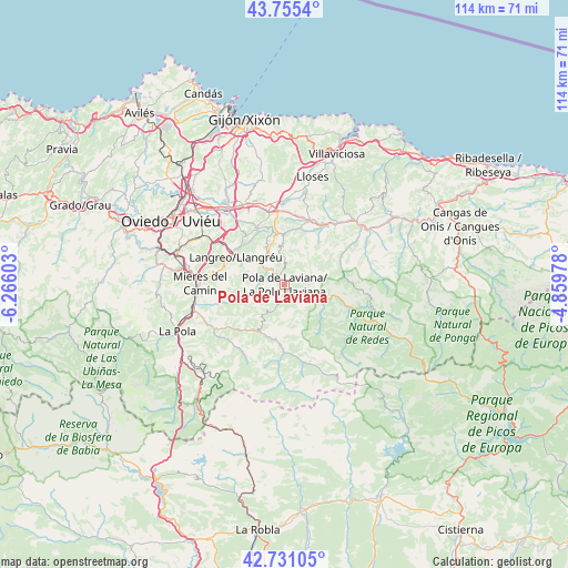
Pola de Laviana GPS coordinates[2]
43° 14' 43.368" North, 5° 33' 46.44" West
| Map corner | latitude | longitude |
|---|---|---|
| Upper-left | 43.7554°, | -6.26603° |
| Center: | 43.24538°, | -5.5629° |
| Lower-right: | 42.73105°, | -4.85978° |
| Map W x H: | 113.9×113.9 km | = 70.8×70.8mi |
| max Lat: | 43.74134° ⇑3.2% North |
| Pola de Laviana: | 43.24538° |
| min Lat: | ⇓96.8% South 27.64134° |
| min Long | Pola de Laviana | max Long |
| -18.00367° | -5.5629° | 4.2899° |
| W 20.4%⇐ | ⇒79.6% E |
Elevation
Elevation of Pola de Laviana is 296 m = 971 ft, and this is 302 m = 991 ft below average elevation for this country.
| Max E: |
1682 m = 5518 ft | 75% |
| Avg. | 598 m = 1962 ft | |
| Pola de Laviana | 296 m = 971 ft | |
Min E: |
0 m = 0 ft | 25% |
See also: Spain elevation on elevation.city.
Geographical zone
Pola de Laviana is located in North temperate zone (between Tropic of Cancer and the Arctic Circle). Distance of this Northern Tropic circle is 2202.5 km =1368.6 mi to South.| Distance of | km | miles | from Pola de Laviana |
|---|---|---|---|
| North Pole | 5198.6 | 3230.3 | to North |
| Arctic Circle | 2592.7 | 1611 | to North |
| Tropic Cancer | 2202.5 | 1368.6 | to South |
| Equator | 4808.4 | 2987.8 | to South |


Nearby cities:
15 places around Pola de Laviana: (largest is in red/bold)
• Bimenes
8 km =5 mi,  7°
7°
• Campo de Caso
19 km =11.8 mi,  111°
111°
• El entrego
7.7 km =4.8 mi,  307°
307°
• Lugones
26.7 km =16.6 mi, 310°
• Mieres
16.5 km =10.3 mi,  271°
271°
• Nava
13.2 km =8.2 mi,  18°
18°
• Noreña
20.2 km =12.6 mi,  324°
324°
• Oviedo
26.1 km =16.2 mi,  299°
299°
• Piloña
19.7 km =12.2 mi,  53°
53°
• Pola de Lena
23.5 km =14.6 mi,  246°
246°
• Pola de Siero
18.2 km =11.3 mi,  333°
333°
• Ruayer
21.3 km =13.2 mi,  177°
177°
• Sama
11.3 km =7 mi, 299°
• Santa Eulalia
22.6 km =14 mi,  32°
32°
• Sariego
17.4 km =10.8 mi, 7°
Sources, notices
• [Note1] Compared only with cities in Spain existing in our database
• [Src1] Map data: © OpenStreetMap contributors (CC-BY-SA)
• [Src2] Other city data from geonames.org with taken over terms of usage.
• [Src3] Geographical zone / Annual Mean Temperature by Robert A. Rohde @ Wikipedia
