Constantí geodata
Constantí (Catalonia) is a seat of a third-order administrative division; located in Spain in Europe/Madrid (GMT+2) time zone. With population of 5,597 people, there are 1195 cities with bigger population in this country. Compared to other cities in Spain, 52.1% of cities are located further ↓South; 91.1% of cities are located further ←West and 88.6% of cities have higher elevation than Constantí. Note1


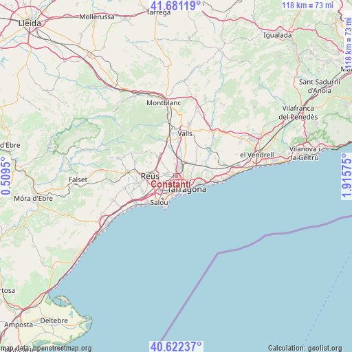
Constantí GPS coordinates[2]
41° 9' 14.112" North, 1° 12' 45.432" East
| Map corner | latitude | longitude |
|---|---|---|
| Upper-left | 41.68119°, | 0.5095° |
| Center: | 41.15392°, | 1.21262° |
| Lower-right: | 40.62237°, | 1.91575° |
| Map W x H: | 117.7×117.7 km | = 73.1×73.1mi |
| max Lat: | 43.74134° ⇑47.9% North |
| Constantí: | 41.15392° |
| min Lat: | ⇓52.1% South 27.64134° |
| min Long | Constantí | max Long |
| -18.00367° | 1.21262° | 4.2899° |
| W 91.1%⇐ | ⇒8.9% E |
Elevation
Elevation of Constantí is 86 m = 282 ft, and this is 512 m = 1680 ft below average elevation for this country.
| Max E: |
1682 m = 5518 ft | 88.6% |
| Avg. | 598 m = 1962 ft | |
| Constantí | 86 m = 282 ft | |
Min E: |
0 m = 0 ft | 11.4% |
See also: Spain elevation on elevation.city.
Geographical zone
Constantí is located in North temperate zone (between Tropic of Cancer and the Arctic Circle). Distance of this Northern Tropic circle is 1970 km =1224.1 mi to South.| Distance of | km | miles | from Constantí |
|---|---|---|---|
| North Pole | 5431.2 | 3374.8 | to North |
| Arctic Circle | 2825.3 | 1755.6 | to North |
| Tropic Cancer | 1970 | 1224.1 | to South |
| Equator | 4575.9 | 2843.3 | to South |


Nearby cities:
15 places around Constantí: (largest is in red/bold)
• Almoster
9.7 km =6 mi,  299°
299°
• La Canonja
4.5 km =2.8 mi,  216°
216°
• La Pineda
8.9 km =5.5 mi,  194°
194°
• La Secuita
8 km =5 mi,  45°
45°
• La Selva del Camp
9.2 km =5.7 mi,  317°
317°
• Perafort
5.5 km =3.4 mi,  40°
40°
• Renau
11.4 km =7.1 mi, 46°
• Reus
8.9 km =5.5 mi,  271°
271°
• Salou
10.5 km =6.5 mi,  214°
214°
• Tarragona
5.2 km =3.2 mi,  142°
142°
• Vallmoll
10.4 km =6.5 mi,  17°
17°
• Vila-seca
7.2 km =4.5 mi,  228°
228°
• el Catllar
8.8 km =5.5 mi,  80°
80°
• els Pallaresos
5.4 km =3.4 mi,  64°
64°
• la Pobla de Mafumet
3.3 km =2.1 mi,  5°
5°
Sources, notices
• [Note1] Compared only with cities in Spain existing in our database
• [Src1] Map data: © OpenStreetMap contributors (CC-BY-SA)
• [Src2] Other city data from geonames.org with taken over terms of usage.
• [Src3] Geographical zone / Annual Mean Temperature by Robert A. Rohde @ Wikipedia
