Pedrosillo de Alba geodata
Pedrosillo de Alba (Castille and León) is a seat of a third-order administrative division; located in Spain in Europe/Madrid (GMT+2) time zone. With population of 216 people, there are 4946 cities with bigger population in this country. Compared to other cities in Spain, 55.6% of cities are located further ↑North; 77.4% of cities are located further →East and 73.2% of cities have lower elevation than Pedrosillo de Alba. Note1
Administrative division(s):
- Level 1: Castille and León
- Level 2: Provincia de Salamanca
- Level 3: Pedrosillo de Alba


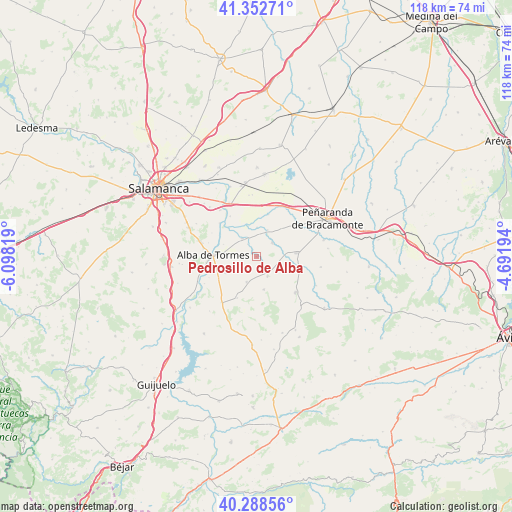
Pedrosillo de Alba GPS coordinates[2]
40° 49' 21.972" North, 5° 23' 42.216" West
| Map corner | latitude | longitude |
|---|---|---|
| Upper-left | 41.35271°, | -6.09819° |
| Center: | 40.82277°, | -5.39506° |
| Lower-right: | 40.28856°, | -4.69194° |
| Map W x H: | 118.3×118.3 km | = 73.5×73.5mi |
| max Lat: | 43.74134° ⇑55.6% North |
| Pedrosillo de Alba: | 40.82277° |
| min Lat: | ⇓44.4% South 27.64134° |
| min Long | Pedrosillo de A | max Long |
| -18.00367° | -5.39506° | 4.2899° |
| W 22.6%⇐ | ⇒77.4% E |
Elevation
Elevation of Pedrosillo de Alba is 837 m = 2746 ft, and this is 239 m = 784 ft above average elevation for this country.
| Max E: |
1682 m = 5518 ft | 26.8% |
| Pedrosillo de Alba | 837 m 2746 ft | |
| Avg. | 598 m = 1962 ft | |
Min E: |
0 m = 0 ft | 73.2% |
See also: Spain elevation on elevation.city.
Geographical zone
Pedrosillo de Alba is located in North temperate zone (between Tropic of Cancer and the Arctic Circle). Distance of this Northern Tropic circle is 1933.1 km =1201.2 mi to South.| Distance of | km | miles | from Pedrosillo de Alba |
|---|---|---|---|
| North Pole | 5468 | 3397.7 | to North |
| Arctic Circle | 2862.1 | 1778.4 | to North |
| Tropic Cancer | 1933.1 | 1201.2 | to South |
| Equator | 4539.1 | 2820.5 | to South |


Nearby cities:
15 places around Pedrosillo de Alba: (largest is in red/bold)
• Alba de Tormes
9.9 km =6.2 mi,  272°
272°
• Alconada
10.2 km =6.3 mi,  15°
15°
• Aldeaseca de Alba
4.4 km =2.7 mi,  264°
264°
• Coca de Alba
6.7 km =4.2 mi, 22°
• Gajates
5.1 km =3.2 mi,  150°
150°
• Garcihernández
5.4 km =3.4 mi,  321°
321°
• Larrodrigo
10.5 km =6.5 mi,  205°
205°
• Macotera
9.3 km =5.8 mi,  84°
84°
• Navales
8 km =5 mi,  241°
241°
• Pedraza de Alba
7.7 km =4.8 mi,  167°
167°
• Peñarandilla
6.8 km =4.2 mi,  1°
1°
• Santiago de la Puebla
9.9 km =6.2 mi,  103°
103°
• Tordillos
4.9 km =3 mi,  46°
46°
• Valdecarros
6.3 km =3.9 mi,  201°
201°
• Villagonzalo de Tormes
11.5 km =7.1 mi,  312°
312°
Sources, notices
• [Note1] Compared only with cities in Spain existing in our database
• [Src1] Map data: © OpenStreetMap contributors (CC-BY-SA)
• [Src2] Other city data from geonames.org with taken over terms of usage.
• [Src3] Geographical zone / Annual Mean Temperature by Robert A. Rohde @ Wikipedia
