Alconada geodata
Alconada (Castille and León) is a seat of a third-order administrative division; located in Spain in Europe/Madrid (GMT+2) time zone. With population of 203 people, there are 5022 cities with bigger population in this country. Compared to other cities in Spain, 53.6% of cities are located further ↑North; 77% of cities are located further →East and 72.6% of cities have lower elevation than Alconada. Note1
Administrative division(s):
- Level 1: Castille and León
- Level 2: Provincia de Salamanca
- Level 3: Alconada


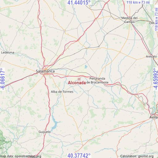
Alconada GPS coordinates[2]
40° 54' 39.312" North, 5° 21' 46.98" West
| Map corner | latitude | longitude |
|---|---|---|
| Upper-left | 41.44015°, | -6.06617° |
| Center: | 40.91092°, | -5.36305° |
| Lower-right: | 40.37742°, | -4.65992° |
| Map W x H: | 118.2×118.2 km | = 73.4×73.4mi |
| max Lat: | 43.74134° ⇑53.6% North |
| Alconada: | 40.91092° |
| min Lat: | ⇓46.4% South 27.64134° |
| min Long | Alconada | max Long |
| -18.00367° | -5.36305° | 4.2899° |
| W 23%⇐ | ⇒77% E |
Elevation
Elevation of Alconada is 831 m = 2726 ft, and this is 233 m = 764 ft above average elevation for this country.
| Max E: |
1682 m = 5518 ft | 27.4% |
| Alconada | 831 m 2726 ft | |
| Avg. | 598 m = 1962 ft | |
Min E: |
0 m = 0 ft | 72.6% |
See also: Spain elevation on elevation.city.
Geographical zone
Alconada is located in North temperate zone (between Tropic of Cancer and the Arctic Circle). Distance of this Northern Tropic circle is 1942.9 km =1207.3 mi to South.| Distance of | km | miles | from Alconada |
|---|---|---|---|
| North Pole | 5458.2 | 3391.6 | to North |
| Arctic Circle | 2852.3 | 1772.3 | to North |
| Tropic Cancer | 1942.9 | 1207.3 | to South |
| Equator | 4548.9 | 2826.6 | to South |


Nearby cities:
15 places around Alconada: (largest is in red/bold)
• Babilafuente
9 km =5.6 mi,  324°
324°
• Coca de Alba
3.6 km =2.2 mi,  183°
183°
• Cordovilla
5.8 km =3.6 mi, 320°
• Encinas de Abajo
9.4 km =5.8 mi,  286°
286°
• Garcihernández
8.3 km =5.2 mi,  227°
227°
• Huerta
10.9 km =6.8 mi,  306°
306°
• Macotera
11 km =6.8 mi,  143°
143°
• Nava de Sotrobal
6.9 km =4.3 mi,  109°
109°
• Pedrosillo de Alba
10.2 km =6.3 mi,  195°
195°
• Peñarandilla
4 km =2.5 mi,  220°
220°
• Tordillos
6.5 km =4 mi,  172°
172°
• Ventosa del Río Almar
2.2 km =1.4 mi,  34°
34°
• Villar de Gallimazo
7.9 km =4.9 mi,  52°
52°
• Villoruela
11.2 km =7 mi,  346°
346°
• Villoría
9.3 km =5.8 mi, 354°
Sources, notices
• [Note1] Compared only with cities in Spain existing in our database
• [Src1] Map data: © OpenStreetMap contributors (CC-BY-SA)
• [Src2] Other city data from geonames.org with taken over terms of usage.
• [Src3] Geographical zone / Annual Mean Temperature by Robert A. Rohde @ Wikipedia
