Garcihernández geodata
Garcihernández (Castille and León) is a seat of a third-order administrative division; located in Spain in Europe/Madrid (GMT+2) time zone. With population of 579 people, there are 3661 cities with bigger population in this country. Compared to other cities in Spain, 54.7% of cities are located further ↑North; 77.8% of cities are located further →East and 70.4% of cities have lower elevation than Garcihernández. Note1
Administrative division(s):
- Level 1: Castille and León
- Level 2: Provincia de Salamanca
- Level 3: Garcihernández


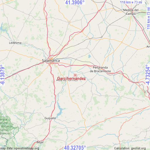
Garcihernández GPS coordinates[2]
40° 51' 39.456" North, 5° 26' 8.412" West
| Map corner | latitude | longitude |
|---|---|---|
| Upper-left | 41.3906°, | -6.13879° |
| Center: | 40.86096°, | -5.43567° |
| Lower-right: | 40.32705°, | -4.73254° |
| Map W x H: | 118.3×118.3 km | = 73.5×73.5mi |
| max Lat: | 43.74134° ⇑54.7% North |
| Garcihernández: | 40.86096° |
| min Lat: | ⇓45.3% South 27.64134° |
| min Long | Garcihernández | max Long |
| -18.00367° | -5.43567° | 4.2899° |
| W 22.2%⇐ | ⇒77.8% E |
Elevation
Elevation of Garcihernández is 817 m = 2680 ft, and this is 219 m = 719 ft above average elevation for this country.
| Max E: |
1682 m = 5518 ft | 29.6% |
| Garcihernández | 817 m 2680 ft | |
| Avg. | 598 m = 1962 ft | |
Min E: |
0 m = 0 ft | 70.4% |
See also: Spain elevation on elevation.city.
Geographical zone
Garcihernández is located in North temperate zone (between Tropic of Cancer and the Arctic Circle). Distance of this Northern Tropic circle is 1937.4 km =1203.8 mi to South.| Distance of | km | miles | from Garcihernández |
|---|---|---|---|
| North Pole | 5463.7 | 3395 | to North |
| Arctic Circle | 2857.9 | 1775.8 | to North |
| Tropic Cancer | 1937.4 | 1203.8 | to South |
| Equator | 4543.3 | 2823.1 | to South |


Nearby cities:
15 places around Garcihernández: (largest is in red/bold)
• Alba de Tormes
7.5 km =4.7 mi,  239°
239°
• Alconada
8.3 km =5.2 mi,  47°
47°
• Aldeaseca de Alba
4.8 km =3 mi,  191°
191°
• Coca de Alba
6.2 km =3.9 mi,  71°
71°
• Cordovilla
10.3 km =6.4 mi,  13°
13°
• Encinas de Abajo
8.7 km =5.4 mi,  340°
340°
• Machacón
10.4 km =6.5 mi,  314°
314°
• Navales
8.8 km =5.5 mi,  204°
204°
• Pedrosillo de Alba
5.4 km =3.4 mi,  141°
141°
• Peñarandilla
4.3 km =2.7 mi, 54°
• Terradillos
9.3 km =5.8 mi,  254°
254°
• Tordillos
7 km =4.3 mi,  97°
97°
• Valdecarros
10.2 km =6.3 mi,  173°
173°
• Ventosa del Río Almar
10.4 km =6.5 mi,  44°
44°
• Villagonzalo de Tormes
6.2 km =3.9 mi,  304°
304°
Sources, notices
• [Note1] Compared only with cities in Spain existing in our database
• [Src1] Map data: © OpenStreetMap contributors (CC-BY-SA)
• [Src2] Other city data from geonames.org with taken over terms of usage.
• [Src3] Geographical zone / Annual Mean Temperature by Robert A. Rohde @ Wikipedia
