Palencia geodata
Palencia (Castille and León) is a seat of a second-order administrative division; located in Spain in Europe/Madrid (GMT+2) time zone. With population of 82,651 people, there are 107 cities with bigger population in this country. Compared to other cities in Spain, 74% of cities are located further ↓South; 66.5% of cities are located further →East and 59.2% of cities have lower elevation than Palencia. Note1
Administrative division(s):
- Level 1: Castille and León
- Level 2: Provincia de Palencia
- Level 3: Palencia


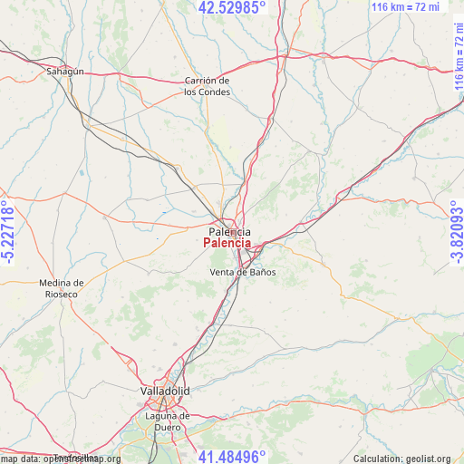
Palencia GPS coordinates[2]
42° 0' 34.38" North, 4° 31' 26.616" West
| Map corner | latitude | longitude |
|---|---|---|
| Upper-left | 42.52985°, | -5.22718° |
| Center: | 42.00955°, | -4.52406° |
| Lower-right: | 41.48496°, | -3.82093° |
| Map W x H: | 116.2×116.2 km | = 72.2×72.2mi |
| max Lat: | 43.74134° ⇑26% North |
| Palencia: | 42.00955° |
| min Lat: | ⇓74% South 27.64134° |
| min Long | Palencia | max Long |
| -18.00367° | -4.52406° | 4.2899° |
| W 33.5%⇐ | ⇒66.5% E |
Elevation
Elevation of Palencia is 739 m = 2425 ft, and this is 141 m = 463 ft above average elevation for this country.
| Max E: |
1682 m = 5518 ft | 40.8% |
| Palencia | 739 m 2425 ft | |
| Avg. | 598 m = 1962 ft | |
Min E: |
0 m = 0 ft | 59.2% |
See also: Palencia elevation on elevation.city.
Geographical zone
Palencia is located in North temperate zone (between Tropic of Cancer and the Arctic Circle). Distance of this Northern Tropic circle is 2065.1 km =1283.2 mi to South.| Distance of | km | miles | from Palencia |
|---|---|---|---|
| North Pole | 5336 | 3315.6 | to North |
| Arctic Circle | 2730.1 | 1696.4 | to North |
| Tropic Cancer | 2065.1 | 1283.2 | to South |
| Equator | 4671 | 2902.4 | to South |


Nearby cities:
15 places around Palencia: (largest is in red/bold)
• Autilla del Pino
9.3 km =5.8 mi,  257°
257°
• Fuentes de Valdepero
7.6 km =4.7 mi,  14°
14°
• Grijota
6.9 km =4.3 mi,  314°
314°
• Husillos
9 km =5.6 mi,  358°
358°
• Magaz
8.6 km =5.3 mi,  111°
111°
• Monzón de Campos
12.1 km =7.5 mi, 12°
• Reinoso de Cerrato
12.2 km =7.6 mi, 107°
• Soto de Cerrato
10 km =6.2 mi,  128°
128°
• Tariego
12.2 km =7.6 mi,  162°
162°
• Valdeolmillos
10.8 km =6.7 mi,  71°
71°
• Venta de Baños
10.2 km =6.3 mi, 164°
• Villalobón
2.9 km =1.8 mi,  36°
36°
• Villamartín de Campos
11.6 km =7.2 mi,  273°
273°
• Villamuriel de Cerrato
6.7 km =4.2 mi,  174°
174°
• Villaumbrales
11.5 km =7.1 mi,  319°
319°
Sources, notices
• [Note1] Compared only with cities in Spain existing in our database
• [Src1] Map data: © OpenStreetMap contributors (CC-BY-SA)
• [Src2] Other city data from geonames.org with taken over terms of usage.
• [Src3] Geographical zone / Annual Mean Temperature by Robert A. Rohde @ Wikipedia
