Grijota geodata
Grijota (Castille and León) is a seat of a third-order administrative division; located in Spain in Europe/Madrid (GMT+2) time zone. With population of 1,047 people, there are 2886 cities with bigger population in this country. Compared to other cities in Spain, 75.2% of cities are located further ↓South; 67.2% of cities are located further →East and 60.3% of cities have lower elevation than Grijota. Note1
Administrative division(s):
- Level 1: Castille and León
- Level 2: Provincia de Palencia
- Level 3: Grijota


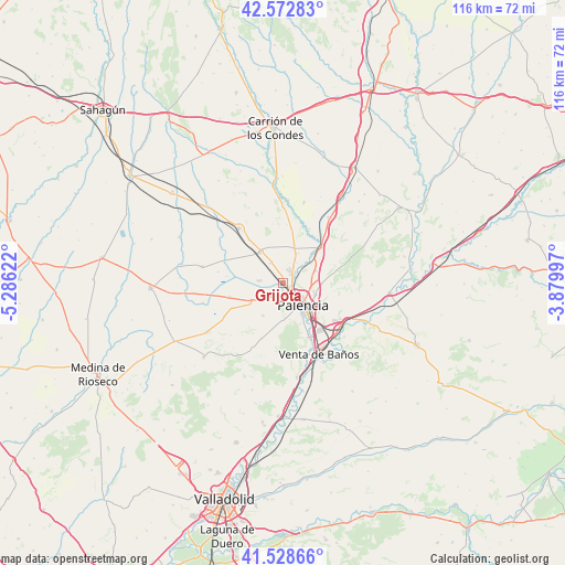
Grijota GPS coordinates[2]
42° 3' 10.404" North, 4° 34' 59.124" West
| Map corner | latitude | longitude |
|---|---|---|
| Upper-left | 42.57283°, | -5.28622° |
| Center: | 42.05289°, | -4.58309° |
| Lower-right: | 41.52866°, | -3.87997° |
| Map W x H: | 116.1×116.1 km | = 72.1×72.1mi |
| max Lat: | 43.74134° ⇑24.8% North |
| Grijota: | 42.05289° |
| min Lat: | ⇓75.2% South 27.64134° |
| min Long | Grijota | max Long |
| -18.00367° | -4.58309° | 4.2899° |
| W 32.8%⇐ | ⇒67.2% E |
Elevation
Elevation of Grijota is 747 m = 2451 ft, and this is 149 m = 489 ft above average elevation for this country.
| Max E: |
1682 m = 5518 ft | 39.7% |
| Grijota | 747 m 2451 ft | |
| Avg. | 598 m = 1962 ft | |
Min E: |
0 m = 0 ft | 60.3% |
See also: Spain elevation on elevation.city.
Geographical zone
Grijota is located in North temperate zone (between Tropic of Cancer and the Arctic Circle). Distance of this Northern Tropic circle is 2069.9 km =1286.2 mi to South.| Distance of | km | miles | from Grijota |
|---|---|---|---|
| North Pole | 5331.2 | 3312.7 | to North |
| Arctic Circle | 2725.3 | 1693.4 | to North |
| Tropic Cancer | 2069.9 | 1286.2 | to South |
| Equator | 4675.8 | 2905.4 | to South |


Nearby cities:
15 places around Grijota: (largest is in red/bold)
• Autilla del Pino
8 km =5 mi,  211°
211°
• Becerril de Campos
7.8 km =4.8 mi,  322°
322°
• Fuentes de Valdepero
7.3 km =4.5 mi,  69°
69°
• Husillos
6.2 km =3.9 mi,  47°
47°
• Mazariegos
11.3 km =7 mi,  255°
255°
• Monzón de Campos
10.2 km =6.3 mi, 46°
• Palencia
6.9 km =4.3 mi,  134°
134°
• Paredes de Nava
14.4 km =8.9 mi, 321°
• Pedraza de Campos
14.7 km =9.1 mi,  238°
238°
• Ribas de Campos
12.4 km =7.7 mi,  26°
26°
• Santa Cecilia del Alcor
14.7 km =9.1 mi,  204°
204°
• Villalobón
7 km =4.3 mi,  110°
110°
• Villamartín de Campos
7.9 km =4.9 mi, 238°
• Villamuriel de Cerrato
12.8 km =8 mi,  154°
154°
• Villaumbrales
4.7 km =2.9 mi,  327°
327°
Sources, notices
• [Note1] Compared only with cities in Spain existing in our database
• [Src1] Map data: © OpenStreetMap contributors (CC-BY-SA)
• [Src2] Other city data from geonames.org with taken over terms of usage.
• [Src3] Geographical zone / Annual Mean Temperature by Robert A. Rohde @ Wikipedia
