Orea geodata
Orea (Castille-La Mancha) is a seat of a third-order administrative division; located in Spain in Europe/Madrid (GMT+2) time zone. With population of 263 people, there are 4672 cities with bigger population in this country. Compared to other cities in Spain, 60.7% of cities are located further ↑North; 70.3% of cities are located further ←West and 99.8% of cities have lower elevation than Orea. Note1
Administrative division(s):
- Level 1: Castille-La Mancha
- Level 2: Provincia de Guadalajara
- Level 3: Orea


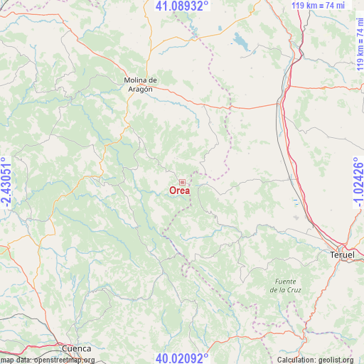
Orea GPS coordinates[2]
40° 33' 26.1" North, 1° 43' 38.568" West
| Map corner | latitude | longitude |
|---|---|---|
| Upper-left | 41.08932°, | -2.43051° |
| Center: | 40.55725°, | -1.72738° |
| Lower-right: | 40.02092°, | -1.02426° |
| Map W x H: | 118.8×118.8 km | = 73.8×73.8mi |
| max Lat: | 43.74134° ⇑60.7% North |
| Orea: | 40.55725° |
| min Lat: | ⇓39.3% South 27.64134° |
| min Long | Orea | max Long |
| -18.00367° | -1.72738° | 4.2899° |
| W 70.3%⇐ | ⇒29.7% E |
Elevation
Elevation of Orea is 1502 m = 4928 ft, and this is 904 m = 2966 ft above average elevation for this country.
| Max E: |
1682 m = 5518 ft | 0.2% |
| Orea | 1502 m 4928 ft | |
| Avg. | 598 m = 1962 ft | |
Min E: |
0 m = 0 ft | 99.8% |
See also: Spain elevation on elevation.city.
Geographical zone
Orea is located in North temperate zone (between Tropic of Cancer and the Arctic Circle). Distance of this Northern Tropic circle is 1903.6 km =1182.8 mi to South.| Distance of | km | miles | from Orea |
|---|---|---|---|
| North Pole | 5497.5 | 3416 | to North |
| Arctic Circle | 2891.6 | 1796.8 | to North |
| Tropic Cancer | 1903.6 | 1182.8 | to South |
| Equator | 4509.5 | 2802.1 | to South |


Nearby cities:
15 places around Orea: (largest is in red/bold)
• Adobes
13.8 km =8.6 mi,  17°
17°
• Alcoroches
7.9 km =4.9 mi,  348°
348°
• Alustante
8.6 km =5.3 mi,  42°
42°
• Bronchales
12.8 km =8 mi,  113°
113°
• Checa
6.2 km =3.9 mi,  301°
301°
• Chequilla
10.1 km =6.3 mi, 302°
• Griegos
14.5 km =9 mi,  174°
174°
• Guadalaviar
18.8 km =11.7 mi,  177°
177°
• Megina
15.1 km =9.4 mi,  307°
307°
• Orihuela del Tremedal
6.6 km =4.1 mi,  97°
97°
• Peralejos de las Truchas
15.9 km =9.9 mi,  284°
284°
• Pinilla de Molina
18.8 km =11.7 mi,  316°
316°
• Piqueras
11.8 km =7.3 mi,  2°
2°
• Tordesilos
16.9 km =10.5 mi, 41°
• Villar del Cobo
18.6 km =11.6 mi, 165°
Sources, notices
• [Note1] Compared only with cities in Spain existing in our database
• [Src1] Map data: © OpenStreetMap contributors (CC-BY-SA)
• [Src2] Other city data from geonames.org with taken over terms of usage.
• [Src3] Geographical zone / Annual Mean Temperature by Robert A. Rohde @ Wikipedia
