Bronchales geodata
Bronchales (Aragon) is a seat of a third-order administrative division; located in Spain in Europe/Madrid (GMT+2) time zone. With population of 452 people, there are 4001 cities with bigger population in this country. Compared to other cities in Spain, 61.5% of cities are located further ↑North; 72.1% of cities are located further ←West and 100% of cities have lower elevation than Bronchales. Note1


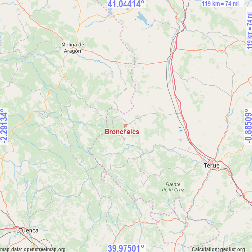
Bronchales GPS coordinates[2]
40° 30' 42.156" North, 1° 35' 17.556" West
| Map corner | latitude | longitude |
|---|---|---|
| Upper-left | 41.04414°, | -2.29134° |
| Center: | 40.51171°, | -1.58821° |
| Lower-right: | 39.97501°, | -0.88509° |
| Map W x H: | 118.9×118.9 km | = 73.9×73.9mi |
| max Lat: | 43.74134° ⇑61.5% North |
| Bronchales: | 40.51171° |
| min Lat: | ⇓38.5% South 27.64134° |
| min Long | Bronchales | max Long |
| -18.00367° | -1.58821° | 4.2899° |
| W 72.1%⇐ | ⇒27.9% E |
Elevation
Elevation of Bronchales is 1582 m = 5190 ft, and this is 984 m = 3228 ft above average elevation for this country.
| Max E: |
1682 m = 5518 ft | 0% |
| Bronchales | 1582 m 5190 ft | |
| Avg. | 598 m = 1962 ft | |
Min E: |
0 m = 0 ft | 100% |
See also: Spain elevation on elevation.city.
Geographical zone
Bronchales is located in North temperate zone (between Tropic of Cancer and the Arctic Circle). Distance of this Northern Tropic circle is 1898.6 km =1179.7 mi to South.| Distance of | km | miles | from Bronchales |
|---|---|---|---|
| North Pole | 5502.6 | 3419.2 | to North |
| Arctic Circle | 2896.7 | 1799.9 | to North |
| Tropic Cancer | 1898.6 | 1179.7 | to South |
| Equator | 4504.5 | 2799 | to South |


Nearby cities:
15 places around Bronchales: (largest is in red/bold)
• Albarracín
16.8 km =10.4 mi,  133°
133°
• Almohaja
16.4 km =10.2 mi,  50°
50°
• Alustante
12.9 km =8 mi,  332°
332°
• Calomarde
15.5 km =9.6 mi,  175°
175°
• Griegos
14.1 km =8.8 mi,  228°
228°
• Monterde de Albarracín
8.3 km =5.2 mi,  101°
101°
• Orea
12.8 km =8 mi,  293°
293°
• Orihuela del Tremedal
6.7 km =4.2 mi,  309°
309°
• Peracense
17.5 km =10.9 mi,  34°
34°
• Pozondón
11.4 km =7.1 mi,  61°
61°
• Royuela
16.1 km =10 mi,  156°
156°
• Ródenas
15.6 km =9.7 mi,  22°
22°
• Torres de Albarracín
10.5 km =6.5 mi,  153°
153°
• Tramacastilla
9.1 km =5.7 mi,  172°
172°
• Villar del Cobo
14.9 km =9.3 mi,  208°
208°
Sources, notices
• [Note1] Compared only with cities in Spain existing in our database
• [Src1] Map data: © OpenStreetMap contributors (CC-BY-SA)
• [Src2] Other city data from geonames.org with taken over terms of usage.
• [Src3] Geographical zone / Annual Mean Temperature by Robert A. Rohde @ Wikipedia
