Oco geodata
Oco (Navarre) is a seat of a third-order administrative division; located in Spain in Europe/Madrid (GMT+2) time zone. With population of 71 people, there are 6234 cities with bigger population in this country. Compared to other cities in Spain, 90.4% of cities are located further ↓South; 65.2% of cities are located further ←West and 62.3% of cities have higher elevation than Oco. Note1


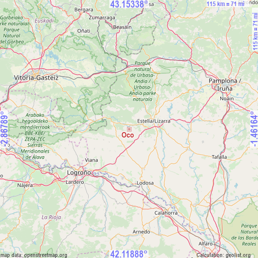
Oco GPS coordinates[2]
42° 38' 17.808" North, 2° 9' 53.136" West
| Map corner | latitude | longitude |
|---|---|---|
| Upper-left | 43.15338°, | -2.86789° |
| Center: | 42.63828°, | -2.16476° |
| Lower-right: | 42.11888°, | -1.46164° |
| Map W x H: | 115×115 km | = 71.5×71.5mi |
| max Lat: | 43.74134° ⇑9.6% North |
| Oco: | 42.63828° |
| min Lat: | ⇓90.4% South 27.64134° |
| min Long | Oco | max Long |
| -18.00367° | -2.16476° | 4.2899° |
| W 65.2%⇐ | ⇒34.8% E |
Elevation
Elevation of Oco is 495 m = 1624 ft, and this is 103 m = 338 ft below average elevation for this country.
| Max E: |
1682 m = 5518 ft | 62.3% |
| Avg. | 598 m = 1962 ft | |
| Oco | 495 m = 1624 ft | |
Min E: |
0 m = 0 ft | 37.7% |
See also: Spain elevation on elevation.city.
Geographical zone
Oco is located in North temperate zone (between Tropic of Cancer and the Arctic Circle). Distance of this Northern Tropic circle is 2135 km =1326.6 mi to South.| Distance of | km | miles | from Oco |
|---|---|---|---|
| North Pole | 5266.1 | 3272.2 | to North |
| Arctic Circle | 2660.2 | 1653 | to North |
| Tropic Cancer | 2135 | 1326.6 | to South |
| Equator | 4740.9 | 2945.9 | to South |


Nearby cities:
15 places around Oco: (largest is in red/bold)
• Abáigar
2.2 km =1.4 mi,  59°
59°
• Ancín
3.2 km =2 mi,  321°
321°
• Arróniz
8.1 km =5 mi,  133°
133°
• Etayo
2.5 km =1.6 mi,  160°
160°
• Igúzquiza
6.5 km =4 mi,  82°
82°
• Legaria
1.4 km =0.9 mi,  328°
328°
• Los Arcos
7.8 km =4.8 mi,  196°
196°
• Metauten
5.2 km =3.2 mi,  33°
33°
• Mirafuentes
9.6 km =6 mi,  259°
259°
• Murieta
2.2 km =1.4 mi,  22°
22°
• Nazar
9.4 km =5.8 mi,  269°
269°
• Olejua
2.5 km =1.6 mi, 131°
• Piedramillera
3.3 km =2.1 mi, 257°
• Sorlada
4.9 km =3 mi,  238°
238°
• Villamayor de Monjardín
5 km =3.1 mi,  101°
101°
Sources, notices
• [Note1] Compared only with cities in Spain existing in our database
• [Src1] Map data: © OpenStreetMap contributors (CC-BY-SA)
• [Src2] Other city data from geonames.org with taken over terms of usage.
• [Src3] Geographical zone / Annual Mean Temperature by Robert A. Rohde @ Wikipedia
