El Molar geodata
El Molar (Madrid) is a populated place; located in Spain in Europe/Madrid (GMT+2) time zone. With population of 5,051 people, there are 1293 cities with bigger population in this country. Compared to other cities in Spain, 57.4% of cities are located further ↑North; 53.3% of cities are located further →East and 73.5% of cities have lower elevation than El Molar. Note1


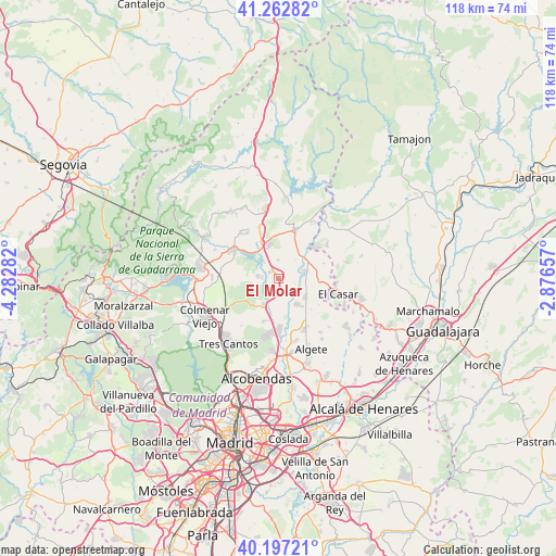
El Molar GPS coordinates[2]
40° 43' 55.74" North, 3° 34' 46.884" West
| Map corner | latitude | longitude |
|---|---|---|
| Upper-left | 41.26282°, | -4.28282° |
| Center: | 40.73215°, | -3.57969° |
| Lower-right: | 40.19721°, | -2.87657° |
| Map W x H: | 118.5×118.5 km | = 73.6×73.6mi |
| max Lat: | 43.74134° ⇑57.4% North |
| El Molar: | 40.73215° |
| min Lat: | ⇓42.6% South 27.64134° |
| min Long | El Molar | max Long |
| -18.00367° | -3.57969° | 4.2899° |
| W 46.7%⇐ | ⇒53.3% E |
Elevation
Elevation of El Molar is 839 m = 2753 ft, and this is 241 m = 791 ft above average elevation for this country.
| Max E: |
1682 m = 5518 ft | 26.5% |
| El Molar | 839 m 2753 ft | |
| Avg. | 598 m = 1962 ft | |
Min E: |
0 m = 0 ft | 73.5% |
See also: Spain elevation on elevation.city.
Geographical zone
El Molar is located in North temperate zone (between Tropic of Cancer and the Arctic Circle). Distance of this Northern Tropic circle is 1923.1 km =1195 mi to South.| Distance of | km | miles | from El Molar |
|---|---|---|---|
| North Pole | 5478.1 | 3403.9 | to North |
| Arctic Circle | 2872.2 | 1784.7 | to North |
| Tropic Cancer | 1923.1 | 1195 | to South |
| Equator | 4529 | 2814.2 | to South |


Nearby cities:
15 places around El Molar: (largest is in red/bold)
• Cabanillas de la Sierra
10.5 km =6.5 mi,  338°
338°
• El Vellón
3.6 km =2.2 mi,  0°
0°
• Fuente el Saz
12.5 km =7.8 mi,  152°
152°
• Guadalix de la Sierra
11.2 km =7 mi,  301°
301°
• La Cabrera
14.9 km =9.3 mi,  349°
349°
• Navalafuente
12.6 km =7.8 mi,  321°
321°
• Pedrezuela
2.1 km =1.3 mi, 304°
• Redueña
9.5 km =5.9 mi, 350°
• San Agustín del Guadalix
6.7 km =4.2 mi,  207°
207°
• Talamanca de Jarama
6.1 km =3.8 mi,  78°
78°
• Torrelaguna
11.2 km =7 mi,  18°
18°
• Torremocha de Jarama
14 km =8.7 mi,  29°
29°
• Valdepiélagos
10.4 km =6.5 mi,  73°
73°
• Valdetorres de Jarama
7.2 km =4.5 mi,  126°
126°
• Venturada
8 km =5 mi,  334°
334°
Sources, notices
• [Note1] Compared only with cities in Spain existing in our database
• [Src1] Map data: © OpenStreetMap contributors (CC-BY-SA)
• [Src2] Other city data from geonames.org with taken over terms of usage.
• [Src3] Geographical zone / Annual Mean Temperature by Robert A. Rohde @ Wikipedia
