Narón geodata
Narón (Galicia) is a seat of a third-order administrative division; located in Spain in Europe/Madrid (GMT+2) time zone. With population of 37,712 people, there are 237 cities with bigger population in this country. Compared to other cities in Spain, 99.5% of cities are located further ↓South; 96.8% of cities are located further →East and 95.4% of cities have higher elevation than Narón. Note1


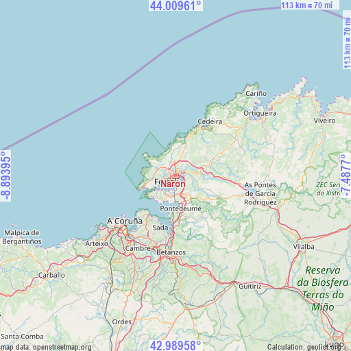
Narón GPS coordinates[2]
43° 30' 6.3" North, 8° 11' 26.952" West
| Map corner | latitude | longitude |
|---|---|---|
| Upper-left | 44.00961°, | -8.89395° |
| Center: | 43.50175°, | -8.19082° |
| Lower-right: | 42.98958°, | -7.4877° |
| Map W x H: | 113.4×113.4 km | = 70.5×70.5mi |
| max Lat: | 43.74134° ⇑0.5% North |
| Narón: | 43.50175° |
| min Lat: | ⇓99.5% South 27.64134° |
| min Long | Narón | max Long |
| -18.00367° | -8.19082° | 4.2899° |
| W 3.2%⇐ | ⇒96.8% E |
Elevation
Elevation of Narón is 23 m = 75 ft, and this is 575 m = 1886 ft below average elevation for this country.
| Max E: |
1682 m = 5518 ft | 95.4% |
| Avg. | 598 m = 1962 ft | |
| Narón | 23 m = 75 ft | |
Min E: |
0 m = 0 ft | 4.6% |
See also: Spain elevation on elevation.city.
Geographical zone
Narón is located in North temperate zone (between Tropic of Cancer and the Arctic Circle). Distance of this Northern Tropic circle is 2231 km =1386.3 mi to South.| Distance of | km | miles | from Narón |
|---|---|---|---|
| North Pole | 5170.1 | 3212.6 | to North |
| Arctic Circle | 2564.2 | 1593.3 | to North |
| Tropic Cancer | 2231 | 1386.3 | to South |
| Equator | 4836.9 | 3005.5 | to South |


Nearby cities:
15 places around Narón: (largest is in red/bold)
• Ares
9 km =5.6 mi,  207°
207°
• Bergondo
20.9 km =13 mi,  189°
189°
• Cedeira
20.7 km =12.9 mi,  31°
31°
• Cerdido
20.3 km =12.6 mi,  49°
49°
• Fene
6.6 km =4.1 mi,  150°
150°
• Ferrol
2.7 km =1.7 mi,  239°
239°
• Franza
6.1 km =3.8 mi,  199°
199°
• Miño
16.9 km =10.5 mi,  182°
182°
• Moeche
15 km =9.3 mi,  69°
69°
• Mugardos
6.9 km =4.3 mi,  228°
228°
• Oleiros
21.3 km =13.2 mi, 208°
• Sada
17.1 km =10.6 mi, 198°
• San Sadurniño
10.6 km =6.6 mi, 70°
• Somozas
21.1 km =13.1 mi,  80°
80°
• Valdoviño
11.9 km =7.4 mi,  22°
22°
Sources, notices
• [Note1] Compared only with cities in Spain existing in our database
• [Src1] Map data: © OpenStreetMap contributors (CC-BY-SA)
• [Src2] Other city data from geonames.org with taken over terms of usage.
• [Src3] Geographical zone / Annual Mean Temperature by Robert A. Rohde @ Wikipedia
