Fene geodata
Fene (Galicia) is a seat of a third-order administrative division; located in Spain in Europe/Madrid (GMT+2) time zone. With population of 14,165 people, there are 651 cities with bigger population in this country. Compared to other cities in Spain, 99.2% of cities are located further ↓South; 96.7% of cities are located further →East and 76.7% of cities have higher elevation than Fene. Note1


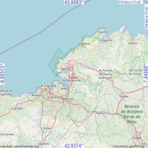
Fene GPS coordinates[2]
43° 27' 0" North, 8° 9' 0" West
| Map corner | latitude | longitude |
|---|---|---|
| Upper-left | 43.9583°, | -8.85313° |
| Center: | 43.45°, | -8.15° |
| Lower-right: | 42.9374°, | -7.44688° |
| Map W x H: | 113.5×113.5 km | = 70.5×70.5mi |
| max Lat: | 43.74134° ⇑0.8% North |
| Fene: | 43.45° |
| min Lat: | ⇓99.2% South 27.64134° |
| min Long | Fene | max Long |
| -18.00367° | -8.15° | 4.2899° |
| W 3.3%⇐ | ⇒96.7% E |
Elevation
Elevation of Fene is 274 m = 899 ft, and this is 324 m = 1063 ft below average elevation for this country.
| Max E: |
1682 m = 5518 ft | 76.7% |
| Avg. | 598 m = 1962 ft | |
| Fene | 274 m = 899 ft | |
Min E: |
0 m = 0 ft | 23.3% |
See also: Spain elevation on elevation.city.
Geographical zone
Fene is located in North temperate zone (between Tropic of Cancer and the Arctic Circle). Distance of this Northern Tropic circle is 2225.3 km =1382.7 mi to South.| Distance of | km | miles | from Fene |
|---|---|---|---|
| North Pole | 5175.9 | 3216.2 | to North |
| Arctic Circle | 2570 | 1596.9 | to North |
| Tropic Cancer | 2225.3 | 1382.7 | to South |
| Equator | 4831.2 | 3002 | to South |


Nearby cities:
15 places around Fene: (largest is in red/bold)
• Ares
7.8 km =4.8 mi,  253°
253°
• Bergondo
16.3 km =10.1 mi,  204°
204°
• Betanzos
19.6 km =12.2 mi, 195°
• Ferrol
7.1 km =4.4 mi,  308°
308°
• Franza
5.4 km =3.4 mi,  270°
270°
• Miño
11.8 km =7.3 mi, 199°
• Moeche
15.5 km =9.6 mi,  44°
44°
• Monfero
16.9 km =10.5 mi,  140°
140°
• Mugardos
8.6 km =5.3 mi,  277°
277°
• Narón
6.6 km =4.1 mi,  330°
330°
• Oleiros
18.7 km =11.6 mi,  226°
226°
• Paderne
18.4 km =11.4 mi,  186°
186°
• Sada
13.6 km =8.5 mi,  219°
219°
• San Sadurniño
11.4 km =7.1 mi, 35°
• Valdoviño
16.7 km =10.4 mi,  4°
4°
Sources, notices
• [Note1] Compared only with cities in Spain existing in our database
• [Src1] Map data: © OpenStreetMap contributors (CC-BY-SA)
• [Src2] Other city data from geonames.org with taken over terms of usage.
• [Src3] Geographical zone / Annual Mean Temperature by Robert A. Rohde @ Wikipedia
