Muruzábal geodata
Muruzábal (Navarre) is a seat of a third-order administrative division; located in Spain in Europe/Madrid (GMT+2) time zone. With population of 304 people, there are 4486 cities with bigger population in this country. Compared to other cities in Spain, 91.4% of cities are located further ↓South; 69.8% of cities are located further ←West and 65.9% of cities have higher elevation than Muruzábal. Note1


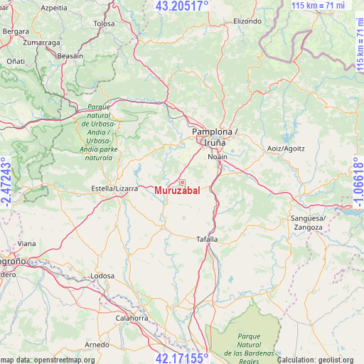
Muruzábal GPS coordinates[2]
42° 41' 25.836" North, 1° 46' 9.516" West
| Map corner | latitude | longitude |
|---|---|---|
| Upper-left | 43.20517°, | -2.47243° |
| Center: | 42.69051°, | -1.76931° |
| Lower-right: | 42.17155°, | -1.06618° |
| Map W x H: | 114.9×114.9 km | = 71.4×71.4mi |
| max Lat: | 43.74134° ⇑8.6% North |
| Muruzábal: | 42.69051° |
| min Lat: | ⇓91.4% South 27.64134° |
| min Long | Muruzábal | max Long |
| -18.00367° | -1.76931° | 4.2899° |
| W 69.8%⇐ | ⇒30.2% E |
Elevation
Elevation of Muruzábal is 447 m = 1467 ft, and this is 151 m = 495 ft below average elevation for this country.
| Max E: |
1682 m = 5518 ft | 65.9% |
| Avg. | 598 m = 1962 ft | |
| Muruzábal | 447 m = 1467 ft | |
Min E: |
0 m = 0 ft | 34.1% |
See also: Spain elevation on elevation.city.
Geographical zone
Muruzábal is located in North temperate zone (between Tropic of Cancer and the Arctic Circle). Distance of this Northern Tropic circle is 2140.8 km =1330.2 mi to South.| Distance of | km | miles | from Muruzábal |
|---|---|---|---|
| North Pole | 5260.3 | 3268.6 | to North |
| Arctic Circle | 2654.4 | 1649.4 | to North |
| Tropic Cancer | 2140.8 | 1330.2 | to South |
| Equator | 4746.7 | 2949.5 | to South |


Nearby cities:
15 places around Muruzábal: (largest is in red/bold)
• Adiós
2.8 km =1.7 mi,  99°
99°
• Artazu
5.7 km =3.5 mi,  271°
271°
• Añorbe
5.8 km =3.6 mi,  129°
129°
• Belascoáin
8.9 km =5.5 mi,  324°
324°
• Cirauqui
10.1 km =6.3 mi,  260°
260°
• Enériz
4 km =2.5 mi,  122°
122°
• Galar
9.8 km =6.1 mi,  36°
36°
• Guirguillano
9.4 km =5.8 mi,  288°
288°
• Legarda
2.4 km =1.5 mi,  1°
1°
• Mañeru
8 km =5 mi,  253°
253°
• Mendigorría
8.7 km =5.4 mi,  217°
217°
• Obanos
1.7 km =1.1 mi,  229°
229°
• Puente la Reina
4.2 km =2.6 mi,  241°
241°
• Tirapu
6.6 km =4.1 mi, 124°
• Uterga
2.3 km =1.4 mi,  19°
19°
Sources, notices
• [Note1] Compared only with cities in Spain existing in our database
• [Src1] Map data: © OpenStreetMap contributors (CC-BY-SA)
• [Src2] Other city data from geonames.org with taken over terms of usage.
• [Src3] Geographical zone / Annual Mean Temperature by Robert A. Rohde @ Wikipedia
