Tirapu geodata
Tirapu (Navarre) is a seat of a third-order administrative division; located in Spain in Europe/Madrid (GMT+2) time zone. With population of 54 people, there are 6416 cities with bigger population in this country. Compared to other cities in Spain, 90.8% of cities are located further ↓South; 70.5% of cities are located further ←West and 61.6% of cities have higher elevation than Tirapu. Note1


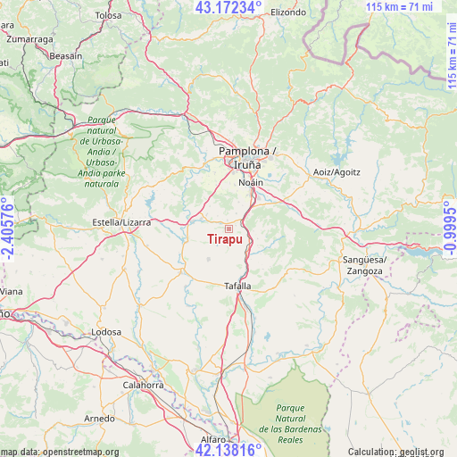
Tirapu GPS coordinates[2]
42° 39' 26.64" North, 1° 42' 9.468" West
| Map corner | latitude | longitude |
|---|---|---|
| Upper-left | 43.17234°, | -2.40576° |
| Center: | 42.6574°, | -1.70263° |
| Lower-right: | 42.13816°, | -0.9995° |
| Map W x H: | 115×115 km | = 71.5×71.5mi |
| max Lat: | 43.74134° ⇑9.2% North |
| Tirapu: | 42.6574° |
| min Lat: | ⇓90.8% South 27.64134° |
| min Long | Tirapu | max Long |
| -18.00367° | -1.70263° | 4.2899° |
| W 70.5%⇐ | ⇒29.5% E |
Elevation
Elevation of Tirapu is 503 m = 1650 ft, and this is 95 m = 312 ft below average elevation for this country.
| Max E: |
1682 m = 5518 ft | 61.6% |
| Avg. | 598 m = 1962 ft | |
| Tirapu | 503 m = 1650 ft | |
Min E: |
0 m = 0 ft | 38.4% |
See also: Spain elevation on elevation.city.
Geographical zone
Tirapu is located in North temperate zone (between Tropic of Cancer and the Arctic Circle). Distance of this Northern Tropic circle is 2137.1 km =1327.9 mi to South.| Distance of | km | miles | from Tirapu |
|---|---|---|---|
| North Pole | 5264 | 3270.9 | to North |
| Arctic Circle | 2658.1 | 1651.7 | to North |
| Tropic Cancer | 2137.1 | 1327.9 | to South |
| Equator | 4743.1 | 2947.2 | to South |


Nearby cities:
15 places around Tirapu: (largest is in red/bold)
• Adiós
4.2 km =2.6 mi,  320°
320°
• Artajona
9.2 km =5.7 mi,  213°
213°
• Añorbe
1 km =0.6 mi,  269°
269°
• Barásoain
7.6 km =4.7 mi,  142°
142°
• Beriáin
9.7 km =6 mi,  29°
29°
• Enériz
2.6 km =1.6 mi,  306°
306°
• Garínoain
7.9 km =4.9 mi, 143°
• Legarda
8.1 km =5 mi, 318°
• Muruzábal
6.6 km =4.1 mi,  304°
304°
• Obanos
7.2 km =4.5 mi,  291°
291°
• Olóriz
7.8 km =4.8 mi,  108°
108°
• Orísoain
10.2 km =6.3 mi,  127°
127°
• Puente la Reina
9.3 km =5.8 mi,  280°
280°
• Unzué
6.3 km =3.9 mi,  94°
94°
• Uterga
7.5 km =4.7 mi, 321°
Sources, notices
• [Note1] Compared only with cities in Spain existing in our database
• [Src1] Map data: © OpenStreetMap contributors (CC-BY-SA)
• [Src2] Other city data from geonames.org with taken over terms of usage.
• [Src3] Geographical zone / Annual Mean Temperature by Robert A. Rohde @ Wikipedia
