Añorbe geodata
Añorbe (Navarre) is a seat of a third-order administrative division; located in Spain in Europe/Madrid (GMT+2) time zone. In our database, there are 6762 cities with bigger population. Compared to other cities in Spain, 90.8% of cities are located further ↓South; 70.4% of cities are located further ←West and 56.3% of cities have higher elevation than Añorbe. Note1


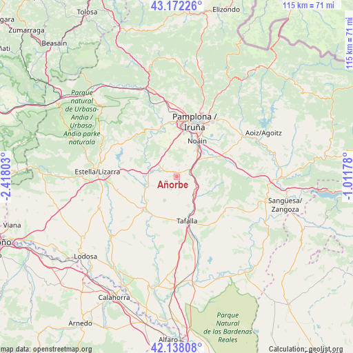
Añorbe GPS coordinates[2]
42° 39' 26.352" North, 1° 42' 53.64" West
| Map corner | latitude | longitude |
|---|---|---|
| Upper-left | 43.17226°, | -2.41803° |
| Center: | 42.65732°, | -1.7149° |
| Lower-right: | 42.13808°, | -1.01178° |
| Map W x H: | 115×115 km | = 71.5×71.5mi |
| max Lat: | 43.74134° ⇑9.2% North |
| Añorbe: | 42.65732° |
| min Lat: | ⇓90.8% South 27.64134° |
| min Long | Añorbe | max Long |
| -18.00367° | -1.7149° | 4.2899° |
| W 70.4%⇐ | ⇒29.6% E |
Elevation
Elevation of Añorbe is 577 m = 1893 ft, and this is 21 m = 69 ft below average elevation for this country.
| Max E: |
1682 m = 5518 ft | 56.3% |
| Avg. | 598 m = 1962 ft | |
| Añorbe | 577 m = 1893 ft | |
Min E: |
0 m = 0 ft | 43.7% |
See also: Spain elevation on elevation.city.
Geographical zone
Añorbe is located in North temperate zone (between Tropic of Cancer and the Arctic Circle). Distance of this Northern Tropic circle is 2137.1 km =1327.9 mi to South.| Distance of | km | miles | from Añorbe |
|---|---|---|---|
| North Pole | 5264 | 3270.9 | to North |
| Arctic Circle | 2658.1 | 1651.7 | to North |
| Tropic Cancer | 2137.1 | 1327.9 | to South |
| Equator | 4743 | 2947.2 | to South |


Nearby cities:
15 places around Añorbe: (largest is in red/bold)
• Adiós
3.6 km =2.2 mi,  332°
332°
• Artajona
8.7 km =5.4 mi,  208°
208°
• Barásoain
8.2 km =5.1 mi,  137°
137°
• Beriáin
10.2 km =6.3 mi,  34°
34°
• Enériz
1.9 km =1.2 mi,  324°
324°
• Garínoain
8.6 km =5.3 mi, 137°
• Legarda
7.5 km =4.7 mi, 324°
• Mendigorría
10.3 km =6.4 mi,  251°
251°
• Muruzábal
5.8 km =3.6 mi,  309°
309°
• Obanos
6.3 km =3.9 mi,  294°
294°
• Olóriz
8.7 km =5.4 mi,  106°
106°
• Puente la Reina
8.3 km =5.2 mi,  282°
282°
• Tirapu
1 km =0.6 mi,  89°
89°
• Unzué
7.3 km =4.5 mi, 94°
• Uterga
6.9 km =4.3 mi, 327°
Sources, notices
• [Note1] Compared only with cities in Spain existing in our database
• [Src1] Map data: © OpenStreetMap contributors (CC-BY-SA)
• [Src2] Other city data from geonames.org with taken over terms of usage.
• [Src3] Geographical zone / Annual Mean Temperature by Robert A. Rohde @ Wikipedia
