Monroyo geodata
Monroyo (Aragon) is a seat of a third-order administrative division; located in Spain in Europe/Madrid (GMT+2) time zone. With population of 316 people, there are 4434 cities with bigger population in this country. Compared to other cities in Spain, 56.4% of cities are located further ↑North; 86.8% of cities are located further ←West and 77.7% of cities have lower elevation than Monroyo. Note1


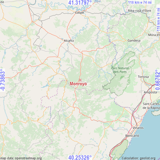
Monroyo GPS coordinates[2]
40° 47' 15.9" North, 0° 2' 7.8" West
| Map corner | latitude | longitude |
|---|---|---|
| Upper-left | 41.31797°, | -0.73863° |
| Center: | 40.78775°, | -0.0355° |
| Lower-right: | 40.25326°, | 0.66762° |
| Map W x H: | 118.4×118.4 km | = 73.6×73.6mi |
| max Lat: | 43.74134° ⇑56.4% North |
| Monroyo: | 40.78775° |
| min Lat: | ⇓43.6% South 27.64134° |
| min Long | Monroyo | max Long |
| -18.00367° | -0.0355° | 4.2899° |
| W 86.8%⇐ | ⇒13.2% E |
Elevation
Elevation of Monroyo is 876 m = 2874 ft, and this is 278 m = 912 ft above average elevation for this country.
| Max E: |
1682 m = 5518 ft | 22.3% |
| Monroyo | 876 m 2874 ft | |
| Avg. | 598 m = 1962 ft | |
Min E: |
0 m = 0 ft | 77.7% |
See also: Spain elevation on elevation.city.
Geographical zone
Monroyo is located in North temperate zone (between Tropic of Cancer and the Arctic Circle). Distance of this Northern Tropic circle is 1929.3 km =1198.8 mi to South.| Distance of | km | miles | from Monroyo |
|---|---|---|---|
| North Pole | 5471.9 | 3400.1 | to North |
| Arctic Circle | 2866 | 1780.8 | to North |
| Tropic Cancer | 1929.3 | 1198.8 | to South |
| Equator | 4535.2 | 2818 | to South |


Nearby cities:
15 places around Monroyo: (largest is in red/bold)
• Aguaviva
14 km =8.7 mi,  285°
285°
• Castell de Cabres
15.6 km =9.7 mi,  155°
155°
• Fuentespalda
8.7 km =5.4 mi,  76°
76°
• Fórnoles
12.1 km =7.5 mi,  12°
12°
• Herbés
7.9 km =4.9 mi, 160°
• La Ginebrosa
12.4 km =7.7 mi,  317°
317°
• Mas de las Matas
18.2 km =11.3 mi, 286°
• Palanques
14.4 km =8.9 mi,  237°
237°
• Peñarroya de Tastavíns
7.3 km =4.5 mi,  118°
118°
• Ráfales
7.2 km =4.5 mi,  39°
39°
• Torre de Arcas
4.9 km =3 mi,  214°
214°
• Torrevelilla
14.2 km =8.8 mi,  333°
333°
• Valderrobres
18.5 km =11.5 mi,  59°
59°
• Villores
18.7 km =11.6 mi,  227°
227°
• Zorita del Maestrazgo
12.9 km =8 mi, 239°
Sources, notices
• [Note1] Compared only with cities in Spain existing in our database
• [Src1] Map data: © OpenStreetMap contributors (CC-BY-SA)
• [Src2] Other city data from geonames.org with taken over terms of usage.
• [Src3] Geographical zone / Annual Mean Temperature by Robert A. Rohde @ Wikipedia
