Moralzarzal geodata
Moralzarzal (Madrid) is a seat of a third-order administrative division; located in Spain in Europe/Madrid (GMT+2) time zone. With population of 11,582 people, there are 764 cities with bigger population in this country. Compared to other cities in Spain, 58.3% of cities are located further ↑North; 59.3% of cities are located further →East and 86.6% of cities have lower elevation than Moralzarzal. Note1


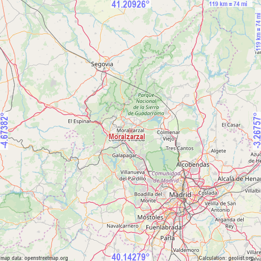
Moralzarzal GPS coordinates[2]
40° 40' 41.376" North, 3° 58' 14.52" West
| Map corner | latitude | longitude |
|---|---|---|
| Upper-left | 41.20926°, | -4.67382° |
| Center: | 40.67816°, | -3.9707° |
| Lower-right: | 40.14279°, | -3.26757° |
| Map W x H: | 118.6×118.6 km | = 73.7×73.7mi |
| max Lat: | 43.74134° ⇑58.3% North |
| Moralzarzal: | 40.67816° |
| min Lat: | ⇓41.7% South 27.64134° |
| min Long | Moralzarzal | max Long |
| -18.00367° | -3.9707° | 4.2899° |
| W 40.7%⇐ | ⇒59.3% E |
Elevation
Elevation of Moralzarzal is 975 m = 3199 ft, and this is 377 m = 1237 ft above average elevation for this country.
| Max E: |
1682 m = 5518 ft | 13.4% |
| Moralzarzal | 975 m 3199 ft | |
| Avg. | 598 m = 1962 ft | |
Min E: |
0 m = 0 ft | 86.6% |
See also: Spain elevation on elevation.city.
Geographical zone
Moralzarzal is located in North temperate zone (between Tropic of Cancer and the Arctic Circle). Distance of this Northern Tropic circle is 1917.1 km =1191.2 mi to South.| Distance of | km | miles | from Moralzarzal |
|---|---|---|---|
| North Pole | 5484.1 | 3407.7 | to North |
| Arctic Circle | 2878.2 | 1788.4 | to North |
| Tropic Cancer | 1917.1 | 1191.2 | to South |
| Equator | 4523 | 2810.5 | to South |


Nearby cities:
15 places around Moralzarzal: (largest is in red/bold)
• Alpedrete
5.1 km =3.2 mi,  244°
244°
• Becerril de la Sierra
4.6 km =2.9 mi,  340°
340°
• Boalo
6.2 km =3.9 mi,  47°
47°
• Cercedilla
10.1 km =6.3 mi,  314°
314°
• Collado Mediano
4.7 km =2.9 mi,  290°
290°
• Collado-Villalba
5.6 km =3.5 mi,  211°
211°
• Colmenarejo
13.6 km =8.5 mi,  196°
196°
• Galapagar
11.5 km =7.1 mi,  194°
194°
• Guadarrama
10 km =6.2 mi,  266°
266°
• Hoyo de Manzanares
8.2 km =5.1 mi,  139°
139°
• Los Molinos
9.7 km =6 mi,  295°
295°
• Manzanares el Real
10.6 km =6.6 mi,  59°
59°
• Navacerrada
6.9 km =4.3 mi,  325°
325°
• Navalquejigo
10.3 km =6.4 mi,  220°
220°
• Torrelodones
11.9 km =7.4 mi,  161°
161°
Sources, notices
• [Note1] Compared only with cities in Spain existing in our database
• [Src1] Map data: © OpenStreetMap contributors (CC-BY-SA)
• [Src2] Other city data from geonames.org with taken over terms of usage.
• [Src3] Geographical zone / Annual Mean Temperature by Robert A. Rohde @ Wikipedia
