Cercedilla geodata
Cercedilla (Madrid) is a seat of a third-order administrative division; located in Spain in Europe/Madrid (GMT+2) time zone. With population of 6,747 people, there are 1064 cities with bigger population in this country. Compared to other cities in Spain, 57.3% of cities are located further ↑North; 60.6% of cities are located further →East and 96.6% of cities have lower elevation than Cercedilla. Note1


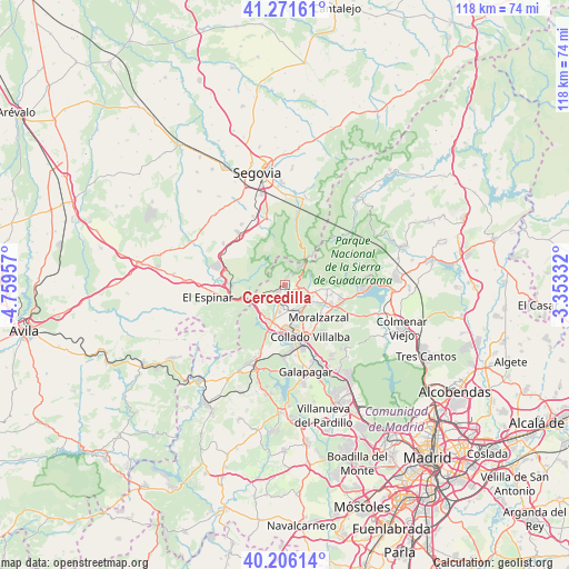
Cercedilla GPS coordinates[2]
40° 44' 27.636" North, 4° 3' 23.184" West
| Map corner | latitude | longitude |
|---|---|---|
| Upper-left | 41.27161°, | -4.75957° |
| Center: | 40.74101°, | -4.05644° |
| Lower-right: | 40.20614°, | -3.35332° |
| Map W x H: | 118.5×118.5 km | = 73.6×73.6mi |
| max Lat: | 43.74134° ⇑57.3% North |
| Cercedilla: | 40.74101° |
| min Lat: | ⇓42.7% South 27.64134° |
| min Long | Cercedilla | max Long |
| -18.00367° | -4.05644° | 4.2899° |
| W 39.4%⇐ | ⇒60.6% E |
Elevation
Elevation of Cercedilla is 1194 m = 3917 ft, and this is 596 m = 1955 ft above average elevation for this country.
| Max E: |
1682 m = 5518 ft | 3.4% |
| Cercedilla | 1194 m 3917 ft | |
| Avg. | 598 m = 1962 ft | |
Min E: |
0 m = 0 ft | 96.6% |
See also: Spain elevation on elevation.city.
Geographical zone
Cercedilla is located in North temperate zone (between Tropic of Cancer and the Arctic Circle). Distance of this Northern Tropic circle is 1924.1 km =1195.6 mi to South.| Distance of | km | miles | from Cercedilla |
|---|---|---|---|
| North Pole | 5477.1 | 3403.3 | to North |
| Arctic Circle | 2871.2 | 1784.1 | to North |
| Tropic Cancer | 1924.1 | 1195.6 | to South |
| Equator | 4530 | 2814.8 | to South |


Nearby cities:
15 places around Cercedilla: (largest is in red/bold)
• Alpedrete
9.5 km =5.9 mi,  163°
163°
• Becerril de la Sierra
6.3 km =3.9 mi,  115°
115°
• Boalo
12.1 km =7.5 mi,  103°
103°
• Collado Mediano
6 km =3.7 mi,  151°
151°
• Collado-Villalba
12.6 km =7.8 mi, 159°
• Guadarrama
8.1 km =5 mi,  200°
200°
• Hoyo de Manzanares
18.2 km =11.3 mi,  136°
136°
• Los Molinos
3.2 km =2 mi,  207°
207°
• Los Ángeles de San Rafael
14 km =8.7 mi,  286°
286°
• Manzanares el Real
16.4 km =10.2 mi, 95°
• Moralzarzal
10.1 km =6.3 mi,  134°
134°
• Navacerrada
3.6 km =2.2 mi,  111°
111°
• Navalquejigo
14.9 km =9.3 mi,  177°
177°
• Ortigosa del Monte
15.1 km =9.4 mi,  317°
317°
• Otero de Herreros
15.6 km =9.7 mi,  304°
304°
Sources, notices
• [Note1] Compared only with cities in Spain existing in our database
• [Src1] Map data: © OpenStreetMap contributors (CC-BY-SA)
• [Src2] Other city data from geonames.org with taken over terms of usage.
• [Src3] Geographical zone / Annual Mean Temperature by Robert A. Rohde @ Wikipedia
