Galapagar geodata
Galapagar (Madrid) is a seat of a third-order administrative division; located in Spain in Europe/Madrid (GMT+2) time zone. With population of 31,820 people, there are 280 cities with bigger population in this country. Compared to other cities in Spain, 60.3% of cities are located further ↑North; 59.7% of cities are located further →East and 78.4% of cities have lower elevation than Galapagar. Note1


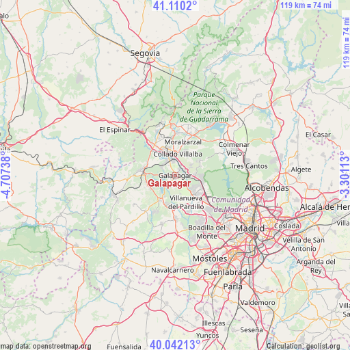
Galapagar GPS coordinates[2]
40° 34' 41.88" North, 4° 0' 15.336" West
| Map corner | latitude | longitude |
|---|---|---|
| Upper-left | 41.1102°, | -4.70738° |
| Center: | 40.5783°, | -4.00426° |
| Lower-right: | 40.04213°, | -3.30113° |
| Map W x H: | 118.8×118.8 km | = 73.8×73.8mi |
| max Lat: | 43.74134° ⇑60.3% North |
| Galapagar: | 40.5783° |
| min Lat: | ⇓39.7% South 27.64134° |
| min Long | Galapagar | max Long |
| -18.00367° | -4.00426° | 4.2899° |
| W 40.3%⇐ | ⇒59.7% E |
Elevation
Elevation of Galapagar is 883 m = 2897 ft, and this is 285 m = 935 ft above average elevation for this country.
| Max E: |
1682 m = 5518 ft | 21.6% |
| Galapagar | 883 m 2897 ft | |
| Avg. | 598 m = 1962 ft | |
Min E: |
0 m = 0 ft | 78.4% |
See also: Spain elevation on elevation.city.
Geographical zone
Galapagar is located in North temperate zone (between Tropic of Cancer and the Arctic Circle). Distance of this Northern Tropic circle is 1906 km =1184.3 mi to South.| Distance of | km | miles | from Galapagar |
|---|---|---|---|
| North Pole | 5495.2 | 3414.6 | to North |
| Arctic Circle | 2889.3 | 1795.3 | to North |
| Tropic Cancer | 1906 | 1184.3 | to South |
| Equator | 4511.9 | 2803.6 | to South |


Nearby cities:
15 places around Galapagar: (largest is in red/bold)
• Alpedrete
9.1 km =5.7 mi,  348°
348°
• Collado Mediano
12.9 km =8 mi, 353°
• Collado-Villalba
6.3 km =3.9 mi,  359°
359°
• Colmenarejo
2.2 km =1.4 mi,  208°
208°
• El Escorial
10.5 km =6.5 mi,  272°
272°
• Guadarrama
12.7 km =7.9 mi,  325°
325°
• Hoyo de Manzanares
9.6 km =6 mi,  58°
58°
• Las Matas
9.8 km =6.1 mi,  103°
103°
• Las Rozas de Madrid
14.6 km =9.1 mi,  130°
130°
• Moralzarzal
11.5 km =7.1 mi,  14°
14°
• Navalquejigo
5 km =3.1 mi,  309°
309°
• San Lorenzo de El Escorial
12.2 km =7.6 mi,  276°
276°
• Torrelodones
6.6 km =4.1 mi,  91°
91°
• Valdemorillo
10.1 km =6.3 mi, 211°
• Villanueva del Pardillo
10.4 km =6.5 mi,  160°
160°
Sources, notices
• [Note1] Compared only with cities in Spain existing in our database
• [Src1] Map data: © OpenStreetMap contributors (CC-BY-SA)
• [Src2] Other city data from geonames.org with taken over terms of usage.
• [Src3] Geographical zone / Annual Mean Temperature by Robert A. Rohde @ Wikipedia
