Mironcillo geodata
Mironcillo (Castille and León) is a seat of a third-order administrative division; located in Spain in Europe/Madrid (GMT+2) time zone. With population of 136 people, there are 5534 cities with bigger population in this country. Compared to other cities in Spain, 60.7% of cities are located further ↑North; 69.9% of cities are located further →East and 94.7% of cities have lower elevation than Mironcillo. Note1
Administrative division(s):
- Level 1: Castille and León
- Level 2: Provincia de Ávila
- Level 3: Mironcillo


Mironcillo GPS coordinates[2]
40° 33' 15.66" North, 4° 49' 28.164" West
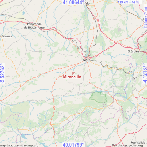
| Map corner | latitude | longitude |
|---|---|---|
| Upper-left | 41.08644°, | -5.52762° |
| Center: | 40.55435°, | -4.82449° |
| Lower-right: | 40.01799°, | -4.12137° |
| Map W x H: | 118.8×118.8 km | = 73.8×73.8mi |
| max Lat: | 43.74134° ⇑60.7% North |
| Mironcillo: | 40.55435° |
| min Lat: | ⇓39.3% South 27.64134° |
| min Long | Mironcillo | max Long |
| -18.00367° | -4.82449° | 4.2899° |
| W 30.1%⇐ | ⇒69.9% E |
Elevation
Elevation of Mironcillo is 1129 m = 3704 ft, and this is 531 m = 1742 ft above average elevation for this country.
| Max E: |
1682 m = 5518 ft | 5.3% |
| Mironcillo | 1129 m 3704 ft | |
| Avg. | 598 m = 1962 ft | |
Min E: |
0 m = 0 ft | 94.7% |
See also: Spain elevation on elevation.city.
Geographical zone
Mironcillo is located in North temperate zone (between Tropic of Cancer and the Arctic Circle). Distance of this Northern Tropic circle is 1903.3 km =1182.7 mi to South.| Distance of | km | miles | from Mironcillo |
|---|---|---|---|
| North Pole | 5497.8 | 3416.2 | to North |
| Arctic Circle | 2892 | 1797 | to North |
| Tropic Cancer | 1903.3 | 1182.7 | to South |
| Equator | 4509.2 | 2801.9 | to South |


Nearby cities:
15 places around Mironcillo: (largest is in red/bold)
• Gemuño
5.5 km =3.4 mi,  41°
41°
• Martiherrero
13.8 km =8.6 mi,  15°
15°
• Muñogalindo
8.3 km =5.2 mi,  310°
310°
• Muñopepe
8.9 km =5.5 mi,  3°
3°
• Narros del Puerto
14.3 km =8.9 mi,  264°
264°
• Navalmoral
11.5 km =7.1 mi,  155°
155°
• Navarredondilla
11.1 km =6.9 mi,  178°
178°
• Niharra
4.1 km =2.5 mi,  342°
342°
• Padiernos
7.7 km =4.8 mi,  346°
346°
• Salobral
6.5 km =4 mi,  10°
10°
• San Juan de la Nava
14.7 km =9.1 mi,  124°
124°
• San Juan del Molinillo
10.6 km =6.6 mi, 176°
• Sanchorreja
14.5 km =9 mi,  328°
328°
• Solosancho
6.8 km =4.2 mi,  268°
268°
• Sotalbo
2.3 km =1.4 mi,  231°
231°
Sources, notices
• [Note1] Compared only with cities in Spain existing in our database
• [Src1] Map data: © OpenStreetMap contributors (CC-BY-SA)
• [Src2] Other city data from geonames.org with taken over terms of usage.
• [Src3] Geographical zone / Annual Mean Temperature by Robert A. Rohde @ Wikipedia
