Salobral geodata
Salobral (Castille and León) is a seat of a third-order administrative division; located in Spain in Europe/Madrid (GMT+2) time zone. With population of 118 people, there are 5722 cities with bigger population in this country. Compared to other cities in Spain, 59.6% of cities are located further ↑North; 69.8% of cities are located further →East and 92.8% of cities have lower elevation than Salobral. Note1
Administrative division(s):
- Level 1: Castille and León
- Level 2: Provincia de Ávila
- Level 3: Salobral


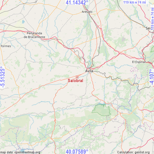
Salobral GPS coordinates[2]
40° 36' 42.444" North, 4° 48' 36.468" West
| Map corner | latitude | longitude |
|---|---|---|
| Upper-left | 41.14342°, | -5.51325° |
| Center: | 40.61179°, | -4.81013° |
| Lower-right: | 40.07589°, | -4.107° |
| Map W x H: | 118.7×118.7 km | = 73.8×73.8mi |
| max Lat: | 43.74134° ⇑59.6% North |
| Salobral: | 40.61179° |
| min Lat: | ⇓40.4% South 27.64134° |
| min Long | Salobral | max Long |
| -18.00367° | -4.81013° | 4.2899° |
| W 30.2%⇐ | ⇒69.8% E |
Elevation
Elevation of Salobral is 1087 m = 3566 ft, and this is 489 m = 1604 ft above average elevation for this country.
| Max E: |
1682 m = 5518 ft | 7.2% |
| Salobral | 1087 m 3566 ft | |
| Avg. | 598 m = 1962 ft | |
Min E: |
0 m = 0 ft | 92.8% |
See also: Spain elevation on elevation.city.
Geographical zone
Salobral is located in North temperate zone (between Tropic of Cancer and the Arctic Circle). Distance of this Northern Tropic circle is 1909.7 km =1186.6 mi to South.| Distance of | km | miles | from Salobral |
|---|---|---|---|
| North Pole | 5491.5 | 3412.3 | to North |
| Arctic Circle | 2885.6 | 1793 | to North |
| Tropic Cancer | 1909.7 | 1186.6 | to South |
| Equator | 4515.6 | 2805.9 | to South |


Nearby cities:
15 places around Salobral: (largest is in red/bold)
• Cardeñosa
15.5 km =9.6 mi,  20°
20°
• Chamartín
16 km =9.9 mi,  309°
309°
• Gemuño
3.3 km =2.1 mi,  133°
133°
• Martiherrero
7.3 km =4.5 mi, 19°
• Mironcillo
6.5 km =4 mi,  190°
190°
• Muñogalindo
7.6 km =4.7 mi,  262°
262°
• Muñopepe
2.6 km =1.6 mi,  343°
343°
• Narrillos del Rebollar
14.4 km =8.9 mi,  294°
294°
• Niharra
3.5 km =2.2 mi,  224°
224°
• Padiernos
3.2 km =2 mi, 290°
• Sanchorreja
10.6 km =6.6 mi,  303°
303°
• Solosancho
10.3 km =6.4 mi,  230°
230°
• Sotalbo
8.3 km =5.2 mi,  200°
200°
• Tornadizos de Ávila
16.6 km =10.3 mi,  83°
83°
• Ávila
10.6 km =6.6 mi,  61°
61°
Sources, notices
• [Note1] Compared only with cities in Spain existing in our database
• [Src1] Map data: © OpenStreetMap contributors (CC-BY-SA)
• [Src2] Other city data from geonames.org with taken over terms of usage.
• [Src3] Geographical zone / Annual Mean Temperature by Robert A. Rohde @ Wikipedia
