Martiherrero geodata
Martiherrero (Castille and León) is a seat of a third-order administrative division; located in Spain in Europe/Madrid (GMT+2) time zone. With population of 202 people, there are 5026 cities with bigger population in this country. Compared to other cities in Spain, 58.4% of cities are located further ↑North; 69.5% of cities are located further →East and 97.6% of cities have lower elevation than Martiherrero. Note1
Administrative division(s):
- Level 1: Castille and León
- Level 2: Provincia de Ávila
- Level 3: Martiherrero


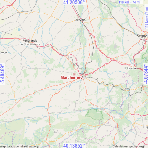
Martiherrero GPS coordinates[2]
40° 40' 26.112" North, 4° 46' 53.616" West
| Map corner | latitude | longitude |
|---|---|---|
| Upper-left | 41.20506°, | -5.48469° |
| Center: | 40.67392°, | -4.78156° |
| Lower-right: | 40.13852°, | -4.07844° |
| Map W x H: | 118.6×118.6 km | = 73.7×73.7mi |
| max Lat: | 43.74134° ⇑58.4% North |
| Martiherrero: | 40.67392° |
| min Lat: | ⇓41.6% South 27.64134° |
| min Long | Martiherrero | max Long |
| -18.00367° | -4.78156° | 4.2899° |
| W 30.5%⇐ | ⇒69.5% E |
Elevation
Elevation of Martiherrero is 1228 m = 4029 ft, and this is 630 m = 2067 ft above average elevation for this country.
| Max E: |
1682 m = 5518 ft | 2.4% |
| Martiherrero | 1228 m 4029 ft | |
| Avg. | 598 m = 1962 ft | |
Min E: |
0 m = 0 ft | 97.6% |
See also: Spain elevation on elevation.city.
Geographical zone
Martiherrero is located in North temperate zone (between Tropic of Cancer and the Arctic Circle). Distance of this Northern Tropic circle is 1916.6 km =1190.9 mi to South.| Distance of | km | miles | from Martiherrero |
|---|---|---|---|
| North Pole | 5484.5 | 3407.9 | to North |
| Arctic Circle | 2878.7 | 1788.7 | to North |
| Tropic Cancer | 1916.6 | 1190.9 | to South |
| Equator | 4522.5 | 2810.2 | to South |


Nearby cities:
15 places around Martiherrero: (largest is in red/bold)
• Aveinte
12.9 km =8 mi,  338°
338°
• Cardeñosa
8.2 km =5.1 mi,  21°
21°
• Gemuño
9.2 km =5.7 mi,  180°
180°
• Mingorría
13.1 km =8.1 mi,  48°
48°
• Mironcillo
13.8 km =8.6 mi,  195°
195°
• Monsalupe
10.6 km =6.6 mi,  0°
0°
• Muñogalindo
12.6 km =7.8 mi,  231°
231°
• Muñopepe
5.4 km =3.4 mi,  215°
215°
• Niharra
10.6 km =6.6 mi,  207°
207°
• Padiernos
7.9 km =4.9 mi, 222°
• Peñalba de Ávila
11.4 km =7.1 mi, 15°
• Salobral
7.3 km =4.5 mi, 199°
• Sanchorreja
11.3 km =7 mi,  264°
264°
• Villaflor
12.2 km =7.6 mi,  320°
320°
• Ávila
7.2 km =4.5 mi,  105°
105°
Sources, notices
• [Note1] Compared only with cities in Spain existing in our database
• [Src1] Map data: © OpenStreetMap contributors (CC-BY-SA)
• [Src2] Other city data from geonames.org with taken over terms of usage.
• [Src3] Geographical zone / Annual Mean Temperature by Robert A. Rohde @ Wikipedia
