Solosancho geodata
Solosancho (Castille and León) is a seat of a third-order administrative division; located in Spain in Europe/Madrid (GMT+2) time zone. With population of 1,021 people, there are 2909 cities with bigger population in this country. Compared to other cities in Spain, 60.8% of cities are located further ↑North; 71.1% of cities are located further →East and 94.5% of cities have lower elevation than Solosancho. Note1
Administrative division(s):
- Level 1: Castille and León
- Level 2: Provincia de Ávila
- Level 3: Solosancho


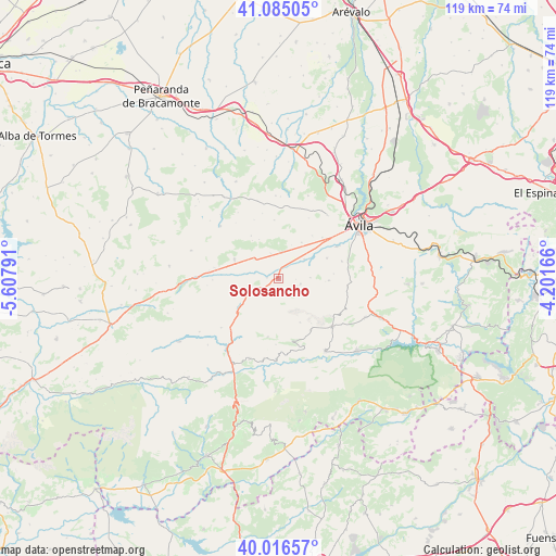
Solosancho GPS coordinates[2]
40° 33' 10.584" North, 4° 54' 17.244" West
| Map corner | latitude | longitude |
|---|---|---|
| Upper-left | 41.08505°, | -5.60791° |
| Center: | 40.55294°, | -4.90479° |
| Lower-right: | 40.01657°, | -4.20166° |
| Map W x H: | 118.8×118.8 km | = 73.8×73.8mi |
| max Lat: | 43.74134° ⇑60.8% North |
| Solosancho: | 40.55294° |
| min Lat: | ⇓39.2% South 27.64134° |
| min Long | Solosancho | max Long |
| -18.00367° | -4.90479° | 4.2899° |
| W 28.9%⇐ | ⇒71.1% E |
Elevation
Elevation of Solosancho is 1126 m = 3694 ft, and this is 528 m = 1732 ft above average elevation for this country.
| Max E: |
1682 m = 5518 ft | 5.5% |
| Solosancho | 1126 m 3694 ft | |
| Avg. | 598 m = 1962 ft | |
Min E: |
0 m = 0 ft | 94.5% |
See also: Spain elevation on elevation.city.
Geographical zone
Solosancho is located in North temperate zone (between Tropic of Cancer and the Arctic Circle). Distance of this Northern Tropic circle is 1903.1 km =1182.5 mi to South.| Distance of | km | miles | from Solosancho |
|---|---|---|---|
| North Pole | 5498 | 3416.3 | to North |
| Arctic Circle | 2892.1 | 1797.1 | to North |
| Tropic Cancer | 1903.1 | 1182.5 | to South |
| Equator | 4509.1 | 2801.8 | to South |


Nearby cities:
15 places around Solosancho: (largest is in red/bold)
• Gemuño
11.2 km =7 mi,  67°
67°
• Mengamuñoz
10 km =6.2 mi,  233°
233°
• Mironcillo
6.8 km =4.2 mi,  88°
88°
• Muñana
10.2 km =6.3 mi,  294°
294°
• Muñogalindo
5.6 km =3.5 mi,  5°
5°
• Muñopepe
11.6 km =7.2 mi,  38°
38°
• Muñotello
11.6 km =7.2 mi,  264°
264°
• Narros del Puerto
7.6 km =4.7 mi, 260°
• Navalacruz
12.8 km =8 mi,  190°
190°
• Niharra
6.9 km =4.3 mi,  53°
53°
• Padiernos
9.1 km =5.7 mi,  33°
33°
• Salobral
10.3 km =6.4 mi, 50°
• San Juan del Molinillo
12.8 km =8 mi,  144°
144°
• Sanchorreja
12.5 km =7.8 mi,  356°
356°
• Sotalbo
5.2 km =3.2 mi,  104°
104°
Sources, notices
• [Note1] Compared only with cities in Spain existing in our database
• [Src1] Map data: © OpenStreetMap contributors (CC-BY-SA)
• [Src2] Other city data from geonames.org with taken over terms of usage.
• [Src3] Geographical zone / Annual Mean Temperature by Robert A. Rohde @ Wikipedia
