Menàrguens geodata
Menàrguens (Catalonia) is a populated place; located in Spain in Europe/Madrid (GMT+2) time zone. With population of 837 people, there are 3150 cities with bigger population in this country. Compared to other cities in Spain, 66.8% of cities are located further ↓South; 89.8% of cities are located further ←West and 81% of cities have higher elevation than Menàrguens. Note1


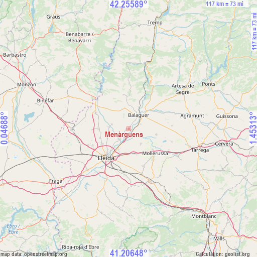
Menàrguens GPS coordinates[2]
41° 43' 59.988" North, 0° 45' 0" East
| Map corner | latitude | longitude |
|---|---|---|
| Upper-left | 42.25589°, | 0.04688° |
| Center: | 41.73333°, | 0.75° |
| Lower-right: | 41.20648°, | 1.45313° |
| Map W x H: | 116.7×116.7 km | = 72.5×72.5mi |
| max Lat: | 43.74134° ⇑33.2% North |
| Menàrguens: | 41.73333° |
| min Lat: | ⇓66.8% South 27.64134° |
| min Long | Menàrguens | max Long |
| -18.00367° | 0.75° | 4.2899° |
| W 89.8%⇐ | ⇒10.2% E |
Elevation
Elevation of Menàrguens is 204 m = 669 ft, and this is 394 m = 1293 ft below average elevation for this country.
| Max E: |
1682 m = 5518 ft | 81% |
| Avg. | 598 m = 1962 ft | |
| Menàrguens | 204 m = 669 ft | |
Min E: |
0 m = 0 ft | 19% |
See also: Spain elevation on elevation.city.
Geographical zone
Menàrguens is located in North temperate zone (between Tropic of Cancer and the Arctic Circle). Distance of this Northern Tropic circle is 2034.4 km =1264.1 mi to South.| Distance of | km | miles | from Menàrguens |
|---|---|---|---|
| North Pole | 5366.8 | 3334.8 | to North |
| Arctic Circle | 2760.9 | 1715.5 | to North |
| Tropic Cancer | 2034.4 | 1264.1 | to South |
| Equator | 4640.3 | 2883.3 | to South |


Nearby cities:
15 places around Menàrguens: (largest is in red/bold)
• Albesa
7.8 km =4.8 mi,  286°
286°
• Alcoletge
10.6 km =6.6 mi,  206°
206°
• Algerri
13.1 km =8.1 mi,  313°
313°
• Alguaire
13.7 km =8.5 mi,  271°
271°
• Balaguer
8.2 km =5.1 mi,  38°
38°
• Bellcaire d'Urgell
14 km =8.7 mi,  82°
82°
• Bellvís
8.8 km =5.5 mi,  140°
140°
• Castelló de Farfanya
9.4 km =5.8 mi,  351°
351°
• Corbins
6.9 km =4.3 mi,  216°
216°
• Sidamon
13.1 km =8.1 mi,  148°
148°
• Torrefarrera
13.6 km =8.5 mi,  240°
240°
• Térmens
2.3 km =1.4 mi, 143°
• Vallfogona de Balaguer
5.7 km =3.5 mi,  68°
68°
• Vilanova de Segrià
11.2 km =7 mi,  260°
260°
• el Poal
11.2 km =7 mi,  119°
119°
Sources, notices
• [Note1] Compared only with cities in Spain existing in our database
• [Src1] Map data: © OpenStreetMap contributors (CC-BY-SA)
• [Src2] Other city data from geonames.org with taken over terms of usage.
• [Src3] Geographical zone / Annual Mean Temperature by Robert A. Rohde @ Wikipedia
