Albesa geodata
Albesa (Catalonia) is a seat of a third-order administrative division; located in Spain in Europe/Madrid (GMT+2) time zone. With population of 1,540 people, there are 2432 cities with bigger population in this country. Compared to other cities in Spain, 67.4% of cities are located further ↓South; 89.5% of cities are located further ←West and 78.7% of cities have higher elevation than Albesa. Note1


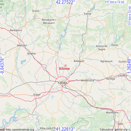
Albesa GPS coordinates[2]
41° 45' 10.152" North, 0° 39' 33.696" East
| Map corner | latitude | longitude |
|---|---|---|
| Upper-left | 42.27522°, | -0.04376° |
| Center: | 41.75282°, | 0.65936° |
| Lower-right: | 41.22613°, | 1.36249° |
| Map W x H: | 116.6×116.6 km | = 72.5×72.5mi |
| max Lat: | 43.74134° ⇑32.6% North |
| Albesa: | 41.75282° |
| min Lat: | ⇓67.4% South 27.64134° |
| min Long | Albesa | max Long |
| -18.00367° | 0.65936° | 4.2899° |
| W 89.5%⇐ | ⇒10.5% E |
Elevation
Elevation of Albesa is 243 m = 797 ft, and this is 355 m = 1165 ft below average elevation for this country.
| Max E: |
1682 m = 5518 ft | 78.7% |
| Avg. | 598 m = 1962 ft | |
| Albesa | 243 m = 797 ft | |
Min E: |
0 m = 0 ft | 21.3% |
See also: Spain elevation on elevation.city.
Geographical zone
Albesa is located in North temperate zone (between Tropic of Cancer and the Arctic Circle). Distance of this Northern Tropic circle is 2036.6 km =1265.5 mi to South.| Distance of | km | miles | from Albesa |
|---|---|---|---|
| North Pole | 5364.6 | 3333.4 | to North |
| Arctic Circle | 2758.7 | 1714.2 | to North |
| Tropic Cancer | 2036.6 | 1265.5 | to South |
| Equator | 4642.5 | 2884.7 | to South |


Nearby cities:
15 places around Albesa: (largest is in red/bold)
• Alcoletge
12 km =7.5 mi,  166°
166°
• Alfarràs
9.5 km =5.9 mi,  318°
318°
• Algerri
7.2 km =4.5 mi,  344°
344°
• Alguaire
6.5 km =4 mi,  254°
254°
• Almenar
8.9 km =5.5 mi,  302°
302°
• Alpicat
13 km =8.1 mi,  221°
221°
• Balaguer
13.3 km =8.3 mi,  71°
71°
• Castelló de Farfanya
9.4 km =5.8 mi,  40°
40°
• Corbins
8.4 km =5.2 mi,  156°
156°
• Menàrguens
7.8 km =4.8 mi,  106°
106°
• Os de Balaguer
14.3 km =8.9 mi,  20°
20°
• Torrefarrera
9.9 km =6.2 mi,  206°
206°
• Térmens
9.8 km =6.1 mi, 114°
• Vallfogona de Balaguer
12.8 km =8 mi,  90°
90°
• Vilanova de Segrià
5.4 km =3.4 mi, 221°
Sources, notices
• [Note1] Compared only with cities in Spain existing in our database
• [Src1] Map data: © OpenStreetMap contributors (CC-BY-SA)
• [Src2] Other city data from geonames.org with taken over terms of usage.
• [Src3] Geographical zone / Annual Mean Temperature by Robert A. Rohde @ Wikipedia
