Balaguer geodata
Balaguer (Catalonia) is a seat of a third-order administrative division; located in Spain in Europe/Madrid (GMT+2) time zone. With population of 16,779 people, there are 565 cities with bigger population in this country. Compared to other cities in Spain, 68.3% of cities are located further ↓South; 89.9% of cities are located further ←West and 79.8% of cities have higher elevation than Balaguer. Note1


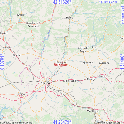
Balaguer GPS coordinates[2]
41° 47' 28.212" North, 0° 48' 39.384" East
| Map corner | latitude | longitude |
|---|---|---|
| Upper-left | 42.31326°, | 0.10781° |
| Center: | 41.79117°, | 0.81094° |
| Lower-right: | 41.26479°, | 1.51406° |
| Map W x H: | 116.6×116.6 km | = 72.5×72.5mi |
| max Lat: | 43.74134° ⇑31.7% North |
| Balaguer: | 41.79117° |
| min Lat: | ⇓68.3% South 27.64134° |
| min Long | Balaguer | max Long |
| -18.00367° | 0.81094° | 4.2899° |
| W 89.9%⇐ | ⇒10.1% E |
Elevation
Elevation of Balaguer is 223 m = 732 ft, and this is 375 m = 1230 ft below average elevation for this country.
| Max E: |
1682 m = 5518 ft | 79.8% |
| Avg. | 598 m = 1962 ft | |
| Balaguer | 223 m = 732 ft | |
Min E: |
0 m = 0 ft | 20.2% |
See also: Spain elevation on elevation.city.
Geographical zone
Balaguer is located in North temperate zone (between Tropic of Cancer and the Arctic Circle). Distance of this Northern Tropic circle is 2040.8 km =1268.1 mi to South.| Distance of | km | miles | from Balaguer |
|---|---|---|---|
| North Pole | 5360.3 | 3330.7 | to North |
| Arctic Circle | 2754.4 | 1711.5 | to North |
| Tropic Cancer | 2040.8 | 1268.1 | to South |
| Equator | 4646.7 | 2887.3 | to South |


Nearby cities:
15 places around Balaguer: (largest is in red/bold)
• Albesa
13.3 km =8.3 mi,  251°
251°
• Algerri
14.7 km =9.1 mi,  280°
280°
• Bellcaire d'Urgell
9.9 km =6.2 mi,  117°
117°
• Bellvís
13.2 km =8.2 mi,  177°
177°
• Camarasa
10.8 km =6.7 mi,  30°
30°
• Castelló de Farfanya
7 km =4.3 mi,  293°
293°
• Cubells
13.9 km =8.6 mi,  61°
61°
• Linyola
13.4 km =8.3 mi,  139°
139°
• Menàrguens
8.2 km =5.1 mi,  218°
218°
• Montgai
12.9 km =8 mi,  85°
85°
• Os de Balaguer
11.8 km =7.3 mi,  320°
320°
• Penelles
13.7 km =8.5 mi,  109°
109°
• Térmens
9.1 km =5.7 mi,  203°
203°
• Vallfogona de Balaguer
4.3 km =2.7 mi, 176°
• el Poal
12.9 km =8 mi,  158°
158°
Sources, notices
• [Note1] Compared only with cities in Spain existing in our database
• [Src1] Map data: © OpenStreetMap contributors (CC-BY-SA)
• [Src2] Other city data from geonames.org with taken over terms of usage.
• [Src3] Geographical zone / Annual Mean Temperature by Robert A. Rohde @ Wikipedia
