Bellcaire d'Urgell geodata
Bellcaire d'Urgell (Catalonia) is a populated place; located in Spain in Europe/Madrid (GMT+2) time zone. With population of 1,218 people, there are 2711 cities with bigger population in this country. Compared to other cities in Spain, 67.3% of cities are located further ↓South; 90.2% of cities are located further ←West and 78.2% of cities have higher elevation than Bellcaire d'Urgell. Note1


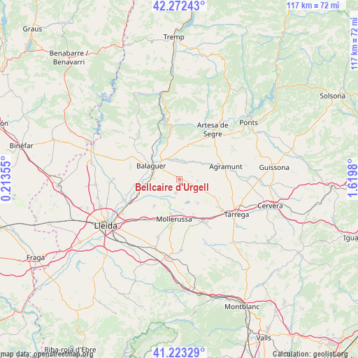
Bellcaire d'Urgell GPS coordinates[2]
41° 45' 0" North, 0° 55' 0.012" East
| Map corner | latitude | longitude |
|---|---|---|
| Upper-left | 42.27243°, | 0.21355° |
| Center: | 41.75°, | 0.91667° |
| Lower-right: | 41.22329°, | 1.6198° |
| Map W x H: | 116.7×116.7 km | = 72.5×72.5mi |
| max Lat: | 43.74134° ⇑32.7% North |
| Bellcaire d'Urgell: | 41.75° |
| min Lat: | ⇓67.3% South 27.64134° |
| min Long | Bellcaire d'Urg | max Long |
| -18.00367° | 0.91667° | 4.2899° |
| W 90.2%⇐ | ⇒9.8% E |
Elevation
Elevation of Bellcaire d'Urgell is 251 m = 823 ft, and this is 347 m = 1138 ft below average elevation for this country.
| Max E: |
1682 m = 5518 ft | 78.2% |
| Avg. | 598 m = 1962 ft | |
| Bellcaire d'Urgell | 251 m = 823 ft | |
Min E: |
0 m = 0 ft | 21.8% |
See also: Spain elevation on elevation.city.
Geographical zone
Bellcaire d'Urgell is located in North temperate zone (between Tropic of Cancer and the Arctic Circle). Distance of this Northern Tropic circle is 2036.2 km =1265.2 mi to South.| Distance of | km | miles | from Bellcaire d'Urgell |
|---|---|---|---|
| North Pole | 5364.9 | 3333.6 | to North |
| Arctic Circle | 2759 | 1714.4 | to North |
| Tropic Cancer | 2036.2 | 1265.2 | to South |
| Equator | 4642.2 | 2884.5 | to South |


Nearby cities:
15 places around Bellcaire d'Urgell: (largest is in red/bold)
• Balaguer
9.9 km =6.2 mi,  297°
297°
• Barbens
11.5 km =7.1 mi,  133°
133°
• Bellvís
11.9 km =7.4 mi,  223°
223°
• Castellnou de Seana
12.2 km =7.6 mi,  158°
158°
• Castellserà
6.9 km =4.3 mi,  90°
90°
• Cubells
11.7 km =7.3 mi,  17°
17°
• Ivars d'Urgell
9.7 km =6 mi,  143°
143°
• La Fuliola
9.3 km =5.8 mi,  115°
115°
• Linyola
5.6 km =3.5 mi,  180°
180°
• Montgai
6.9 km =4.3 mi,  36°
36°
• Penelles
4.1 km =2.5 mi, 90°
• Preixens
12.2 km =7.6 mi,  65°
65°
• Tornabous
12.6 km =7.8 mi, 115°
• Vallfogona de Balaguer
8.5 km =5.3 mi,  271°
271°
• el Poal
8.5 km =5.3 mi,  209°
209°
Sources, notices
• [Note1] Compared only with cities in Spain existing in our database
• [Src1] Map data: © OpenStreetMap contributors (CC-BY-SA)
• [Src2] Other city data from geonames.org with taken over terms of usage.
• [Src3] Geographical zone / Annual Mean Temperature by Robert A. Rohde @ Wikipedia
