l'Alcora geodata
l'Alcora (Valencia) is a populated place; located in Spain in Europe/Madrid (GMT+2) time zone. With population of 11,150 people, there are 790 cities with bigger population in this country. Compared to other cities in Spain, 69.2% of cities are located further ↑North; 85.5% of cities are located further ←West and 79.1% of cities have higher elevation than l'Alcora. Note1


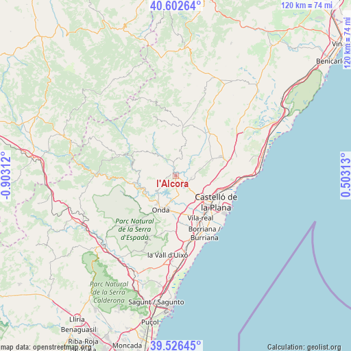
l'Alcora GPS coordinates[2]
40° 4' 0.012" North, 0° 12' 0" West
| Map corner | latitude | longitude |
|---|---|---|
| Upper-left | 40.60264°, | -0.90312° |
| Center: | 40.06667°, | -0.2° |
| Lower-right: | 39.52645°, | 0.50313° |
| Map W x H: | 119.7×119.7 km | = 74.4×74.4mi |
| max Lat: | 43.74134° ⇑69.2% North |
| l'Alcora: | 40.06667° |
| min Lat: | ⇓30.8% South 27.64134° |
| min Long | l'Alcora | max Long |
| -18.00367° | -0.2° | 4.2899° |
| W 85.5%⇐ | ⇒14.5% E |
Elevation
Elevation of l'Alcora is 236 m = 774 ft, and this is 362 m = 1188 ft below average elevation for this country.
| Max E: |
1682 m = 5518 ft | 79.1% |
| Avg. | 598 m = 1962 ft | |
| l'Alcora | 236 m = 774 ft | |
Min E: |
0 m = 0 ft | 20.9% |
See also: Spain elevation on elevation.city.
Geographical zone
l'Alcora is located in North temperate zone (between Tropic of Cancer and the Arctic Circle). Distance of this Northern Tropic circle is 1849.1 km =1149 mi to South.| Distance of | km | miles | from l'Alcora |
|---|---|---|---|
| North Pole | 5552.1 | 3449.9 | to North |
| Arctic Circle | 2946.2 | 1830.7 | to North |
| Tropic Cancer | 1849.1 | 1149 | to South |
| Equator | 4455 | 2768.2 | to South |


Nearby cities:
15 places around l'Alcora: (largest is in red/bold)
• Argelita
12.9 km =8 mi,  261°
261°
• Betxí
14.8 km =9.2 mi,  180°
180°
• Borriol
11.4 km =7.1 mi,  103°
103°
• Costur
6.3 km =3.9 mi,  20°
20°
• Espadilla
13.3 km =8.3 mi,  253°
253°
• Fanzara
11.4 km =7.1 mi,  240°
240°
• Figueroles
6.2 km =3.9 mi,  332°
332°
• Lucena del Cid
10.3 km =6.4 mi,  316°
316°
• Ludiente
14.3 km =8.9 mi,  277°
277°
• Onda
12.4 km =7.7 mi,  204°
204°
• Ribesalbes
7.9 km =4.9 mi,  225°
225°
• San Juan de Moró
5.4 km =3.4 mi, 97°
• Toga
14.3 km =8.9 mi, 262°
• Useras
10.5 km =6.5 mi, 16°
• Villafamés
13.9 km =8.6 mi,  66°
66°
Sources, notices
• [Note1] Compared only with cities in Spain existing in our database
• [Src1] Map data: © OpenStreetMap contributors (CC-BY-SA)
• [Src2] Other city data from geonames.org with taken over terms of usage.
• [Src3] Geographical zone / Annual Mean Temperature by Robert A. Rohde @ Wikipedia
