Sant Feliu de Guíxols geodata
Sant Feliu de Guíxols (Catalonia) is a seat of a third-order administrative division; located in Spain in Europe/Madrid (GMT+2) time zone. With population of 21,977 people, there are 428 cities with bigger population in this country. Compared to other cities in Spain, 68.1% of cities are located further ↓South; 98.9% of cities are located further ←West and 97.9% of cities have higher elevation than Sant Feliu de Guíxols. Note1
Administrative division(s):
- Level 1: Catalonia
- Level 2: Província de Girona
- Level 3: Sant Feliu de Guíxols
Current local time in Sant Feliu de Guíxols:
09:16 PM, ThursdayDifference from your time zone: hours


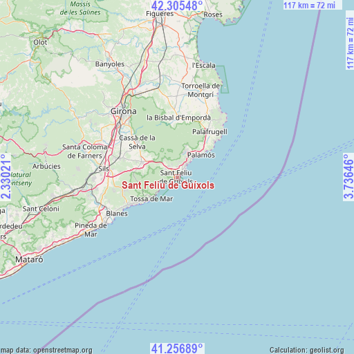
Sant Feliu de Guíxols GPS coordinates[2]
41° 46' 59.988" North, 3° 1' 59.988" East
| Map corner | latitude | longitude |
|---|---|---|
| Upper-left | 42.30548°, | 2.33021° |
| Center: | 41.78333°, | 3.03333° |
| Lower-right: | 41.25689°, | 3.73646° |
| Map W x H: | 116.6×116.6 km | = 72.5×72.5mi |
| max Lat: | 43.74134° ⇑31.9% North |
| Sant Feliu de Guíxols: | 41.78333° |
| min Lat: | ⇓68.1% South 27.64134° |
| min Long | Sant Feliu de G | max Long |
| -18.00367° | 3.03333° | 4.2899° |
| W 98.9%⇐ | ⇒1.1% E |
Elevation
Elevation of Sant Feliu de Guíxols is 12 m = 39 ft, and this is 586 m = 1923 ft below average elevation for this country.
| Max E: |
1682 m = 5518 ft | 97.9% |
| Avg. | 598 m = 1962 ft | |
| Sant Feliu de Guíxols | 12 m = 39 ft | |
Min E: |
0 m = 0 ft | 2.1% |
See also: Spain elevation on elevation.city.
Geographical zone
Sant Feliu de Guíxols is located in North temperate zone (between Tropic of Cancer and the Arctic Circle). Distance of this Northern Tropic circle is 2040 km =1267.6 mi to South.| Distance of | km | miles | from Sant Feliu de Guíxols |
|---|---|---|---|
| North Pole | 5361.2 | 3331.3 | to North |
| Arctic Circle | 2755.3 | 1712.1 | to North |
| Tropic Cancer | 2040 | 1267.6 | to South |
| Equator | 4645.9 | 2886.8 | to South |


Nearby cities:
15 places around Sant Feliu de Guíxols: (largest is in red/bold)
• Caldes de Malavella
18.8 km =11.7 mi,  287°
287°
• Calella de Palafrugell
17.5 km =10.9 mi,  46°
46°
• Calonge
9.2 km =5.7 mi,  24°
24°
• Cassà de la Selva
17.5 km =10.9 mi,  311°
311°
• Castell-Platja d'Aro
4.7 km =2.9 mi,  36°
36°
• Cruïlles
18.6 km =11.6 mi,  355°
355°
• Llagostera
12.5 km =7.8 mi, 292°
• Lloret de Mar
18.1 km =11.2 mi,  239°
239°
• Palafrugell
18.4 km =11.4 mi, 35°
• Palamós
10.7 km =6.6 mi, 47°
• S'Agaró
2 km =1.2 mi,  55°
55°
• Santa Cristina d'Aro
4.6 km =2.9 mi,  323°
323°
• Tossa de Mar
11.1 km =6.9 mi,  228°
228°
• Vall-Llobrega
13.3 km =8.3 mi, 35°
• la Bisbal d'Empordà
18.6 km =11.6 mi,  4°
4°
Sources, notices
• [Note1] Compared only with cities in Spain existing in our database
• [Src1] Map data: © OpenStreetMap contributors (CC-BY-SA)
• [Src2] Other city data from geonames.org with taken over terms of usage.
• [Src3] Geographical zone / Annual Mean Temperature by Robert A. Rohde @ Wikipedia
