Riodeva geodata
Riodeva (Aragon) is a seat of a third-order administrative division; located in Spain in Europe/Madrid (GMT+2) time zone. With population of 193 people, there are 5085 cities with bigger population in this country. Compared to other cities in Spain, 68.5% of cities are located further ↑North; 76% of cities are located further ←West and 85.2% of cities have lower elevation than Riodeva. Note1


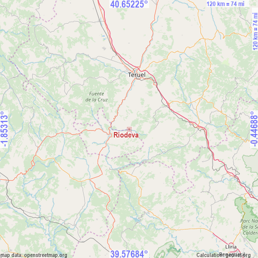
Riodeva GPS coordinates[2]
40° 7' 0.012" North, 1° 9' 0" West
| Map corner | latitude | longitude |
|---|---|---|
| Upper-left | 40.65225°, | -1.85313° |
| Center: | 40.11667°, | -1.15° |
| Lower-right: | 39.57684°, | -0.44688° |
| Map W x H: | 119.6×119.6 km | = 74.3×74.3mi |
| max Lat: | 43.74134° ⇑68.5% North |
| Riodeva: | 40.11667° |
| min Lat: | ⇓31.5% South 27.64134° |
| min Long | Riodeva | max Long |
| -18.00367° | -1.15° | 4.2899° |
| W 76%⇐ | ⇒24% E |
Elevation
Elevation of Riodeva is 953 m = 3127 ft, and this is 355 m = 1165 ft above average elevation for this country.
| Max E: |
1682 m = 5518 ft | 14.8% |
| Riodeva | 953 m 3127 ft | |
| Avg. | 598 m = 1962 ft | |
Min E: |
0 m = 0 ft | 85.2% |
See also: Spain elevation on elevation.city.
Geographical zone
Riodeva is located in North temperate zone (between Tropic of Cancer and the Arctic Circle). Distance of this Northern Tropic circle is 1854.6 km =1152.4 mi to South.| Distance of | km | miles | from Riodeva |
|---|---|---|---|
| North Pole | 5546.5 | 3446.4 | to North |
| Arctic Circle | 2940.6 | 1827.2 | to North |
| Tropic Cancer | 1854.6 | 1152.4 | to South |
| Equator | 4460.6 | 2771.7 | to South |


Nearby cities:
15 places around Riodeva: (largest is in red/bold)
• Ademuz
13.2 km =8.2 mi,  242°
242°
• Arcos de las Salinas
17.8 km =11.1 mi,  146°
146°
• Camarena de la Sierra
10.6 km =6.6 mi,  69°
69°
• Casas Altas
13.6 km =8.5 mi,  226°
226°
• Casas Bajas
14.9 km =9.3 mi,  221°
221°
• Cascante del Río
9.4 km =5.8 mi,  18°
18°
• Castielfabib
13.2 km =8.2 mi,  276°
276°
• Cubla
12 km =7.5 mi,  30°
30°
• Libros
8.8 km =5.5 mi,  306°
306°
• Puebla de San Miguel
7.5 km =4.7 mi,  169°
169°
• Tramacastiel
11.1 km =6.9 mi,  315°
315°
• Valacloche
9.6 km =6 mi, 31°
• Vallanca
16.6 km =10.3 mi,  250°
250°
• Villastar
18.3 km =11.4 mi,  359°
359°
• Villel
13.5 km =8.4 mi,  346°
346°
Sources, notices
• [Note1] Compared only with cities in Spain existing in our database
• [Src1] Map data: © OpenStreetMap contributors (CC-BY-SA)
• [Src2] Other city data from geonames.org with taken over terms of usage.
• [Src3] Geographical zone / Annual Mean Temperature by Robert A. Rohde @ Wikipedia
