Lécera geodata
Lécera (Aragon) is a seat of a third-order administrative division; located in Spain in Europe/Madrid (GMT+2) time zone. With population of 766 people, there are 3279 cities with bigger population in this country. Compared to other cities in Spain, 53.2% of cities are located further ↓South; 79.7% of cities are located further ←West and 59.5% of cities have higher elevation than Lécera. Note1


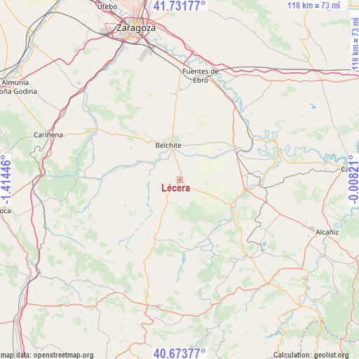
Lécera GPS coordinates[2]
41° 12' 17.676" North, 0° 42' 40.788" West
| Map corner | latitude | longitude |
|---|---|---|
| Upper-left | 41.73177°, | -1.41446° |
| Center: | 41.20491°, | -0.71133° |
| Lower-right: | 40.67377°, | -0.00821° |
| Map W x H: | 117.6×117.6 km | = 73.1×73.1mi |
| max Lat: | 43.74134° ⇑46.8% North |
| Lécera: | 41.20491° |
| min Lat: | ⇓53.2% South 27.64134° |
| min Long | Lécera | max Long |
| -18.00367° | -0.71133° | 4.2899° |
| W 79.7%⇐ | ⇒20.3% E |
Elevation
Elevation of Lécera is 534 m = 1752 ft, and this is 64 m = 210 ft below average elevation for this country.
| Max E: |
1682 m = 5518 ft | 59.5% |
| Avg. | 598 m = 1962 ft | |
| Lécera | 534 m = 1752 ft | |
Min E: |
0 m = 0 ft | 40.5% |
See also: Spain elevation on elevation.city.
Geographical zone
Lécera is located in North temperate zone (between Tropic of Cancer and the Arctic Circle). Distance of this Northern Tropic circle is 1975.6 km =1227.6 mi to South.| Distance of | km | miles | from Lécera |
|---|---|---|---|
| North Pole | 5425.5 | 3371.2 | to North |
| Arctic Circle | 2819.6 | 1752 | to North |
| Tropic Cancer | 1975.6 | 1227.6 | to South |
| Equator | 4581.6 | 2846.9 | to South |


Nearby cities:
15 places around Lécera: (largest is in red/bold)
• Alacón
20 km =12.4 mi,  176°
176°
• Albalate del Arzobispo
19.1 km =11.9 mi,  118°
118°
• Almochuel
15.8 km =9.8 mi,  58°
58°
• Almonacid de la Cuba
10.8 km =6.7 mi,  321°
321°
• Ariño
21.8 km =13.5 mi,  152°
152°
• Azuara
14.6 km =9.1 mi,  293°
293°
• Belchite
11.8 km =7.3 mi,  342°
342°
• Blesa
22.4 km =13.9 mi,  220°
220°
• Híjar
22 km =13.7 mi,  98°
98°
• Lagata
8.7 km =5.4 mi,  296°
296°
• Letux
9.5 km =5.9 mi,  306°
306°
• Moneva
13.5 km =8.4 mi,  230°
230°
• Moyuela
19.6 km =12.2 mi,  244°
244°
• Muniesa
20.9 km =13 mi,  203°
203°
• Samper del Salz
10.1 km =6.3 mi, 289°
Sources, notices
• [Note1] Compared only with cities in Spain existing in our database
• [Src1] Map data: © OpenStreetMap contributors (CC-BY-SA)
• [Src2] Other city data from geonames.org with taken over terms of usage.
• [Src3] Geographical zone / Annual Mean Temperature by Robert A. Rohde @ Wikipedia
