Belchite geodata
Belchite (Aragon) is a populated place; located in Spain in Europe/Madrid (GMT+2) time zone. With population of 1,568 people, there are 2411 cities with bigger population in this country. Compared to other cities in Spain, 55.4% of cities are located further ↓South; 79.4% of cities are located further ←West and 68.1% of cities have higher elevation than Belchite. Note1


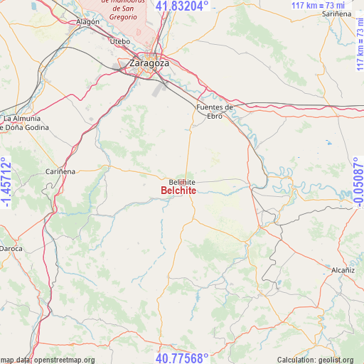
Belchite GPS coordinates[2]
41° 18' 21.6" North, 0° 45' 14.4" West
| Map corner | latitude | longitude |
|---|---|---|
| Upper-left | 41.83204°, | -1.45712° |
| Center: | 41.306°, | -0.754° |
| Lower-right: | 40.77568°, | -0.05087° |
| Map W x H: | 117.5×117.5 km | = 73×73mi |
| max Lat: | 43.74134° ⇑44.6% North |
| Belchite: | 41.306° |
| min Lat: | ⇓55.4% South 27.64134° |
| min Long | Belchite | max Long |
| -18.00367° | -0.754° | 4.2899° |
| W 79.4%⇐ | ⇒20.6% E |
Elevation
Elevation of Belchite is 415 m = 1362 ft, and this is 183 m = 600 ft below average elevation for this country.
| Max E: |
1682 m = 5518 ft | 68.1% |
| Avg. | 598 m = 1962 ft | |
| Belchite | 415 m = 1362 ft | |
Min E: |
0 m = 0 ft | 31.9% |
See also: Spain elevation on elevation.city.
Geographical zone
Belchite is located in North temperate zone (between Tropic of Cancer and the Arctic Circle). Distance of this Northern Tropic circle is 1986.9 km =1234.6 mi to South.| Distance of | km | miles | from Belchite |
|---|---|---|---|
| North Pole | 5414.3 | 3364.3 | to North |
| Arctic Circle | 2808.4 | 1745.1 | to North |
| Tropic Cancer | 1986.9 | 1234.6 | to South |
| Equator | 4592.8 | 2853.8 | to South |


Nearby cities:
15 places around Belchite: (largest is in red/bold)
• Aguilón
24.5 km =15.2 mi,  267°
267°
• Almochuel
17.2 km =10.7 mi,  99°
99°
• Almonacid de la Cuba
4.3 km =2.7 mi,  228°
228°
• Azuara
11.1 km =6.9 mi,  241°
241°
• Fuendetodos
17.7 km =11 mi,  283°
283°
• Lagata
8.5 km =5.3 mi,  209°
209°
• Letux
7 km =4.3 mi,  215°
215°
• Lécera
11.8 km =7.3 mi,  162°
162°
• Mediana
18.3 km =11.4 mi,  12°
12°
• Moneva
20.9 km =13 mi,  199°
199°
• Moyuela
24.3 km =15.1 mi, 215°
• Puebla de Albortón
12.2 km =7.6 mi,  316°
316°
• Samper del Salz
9.9 km =6.2 mi, 216°
• Valmadrid
18.8 km =11.7 mi, 324°
• Villanueva del Huerva
24.2 km =15 mi, 282°
Sources, notices
• [Note1] Compared only with cities in Spain existing in our database
• [Src1] Map data: © OpenStreetMap contributors (CC-BY-SA)
• [Src2] Other city data from geonames.org with taken over terms of usage.
• [Src3] Geographical zone / Annual Mean Temperature by Robert A. Rohde @ Wikipedia
