Larraona geodata
Larraona (Navarre) is a seat of a third-order administrative division; located in Spain in Europe/Madrid (GMT+2) time zone. With population of 140 people, there are 5501 cities with bigger population in this country. Compared to other cities in Spain, 92.4% of cities are located further ↓South; 64.1% of cities are located further ←West and 65% of cities have lower elevation than Larraona. Note1


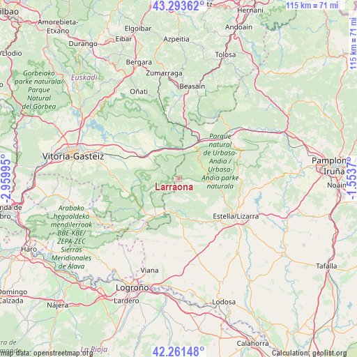
Larraona GPS coordinates[2]
42° 46' 46.92" North, 2° 15' 24.552" West
| Map corner | latitude | longitude |
|---|---|---|
| Upper-left | 43.29362°, | -2.95995° |
| Center: | 42.7797°, | -2.25682° |
| Lower-right: | 42.26148°, | -1.5537° |
| Map W x H: | 114.8×114.8 km | = 71.3×71.3mi |
| max Lat: | 43.74134° ⇑7.6% North |
| Larraona: | 42.7797° |
| min Lat: | ⇓92.4% South 27.64134° |
| min Long | Larraona | max Long |
| -18.00367° | -2.25682° | 4.2899° |
| W 64.1%⇐ | ⇒35.9% E |
Elevation
Elevation of Larraona is 778 m = 2552 ft, and this is 180 m = 591 ft above average elevation for this country.
| Max E: |
1682 m = 5518 ft | 35% |
| Larraona | 778 m 2552 ft | |
| Avg. | 598 m = 1962 ft | |
Min E: |
0 m = 0 ft | 65% |
See also: Spain elevation on elevation.city.
Geographical zone
Larraona is located in North temperate zone (between Tropic of Cancer and the Arctic Circle). Distance of this Northern Tropic circle is 2150.7 km =1336.4 mi to South.| Distance of | km | miles | from Larraona |
|---|---|---|---|
| North Pole | 5250.4 | 3262.4 | to North |
| Arctic Circle | 2644.5 | 1643.2 | to North |
| Tropic Cancer | 2150.7 | 1336.4 | to South |
| Equator | 4756.7 | 2955.7 | to South |


Nearby cities:
15 places around Larraona: (largest is in red/bold)
• Agurain / Salvatierra
13.6 km =8.5 mi,  306°
306°
• Altsasu
15.3 km =9.5 mi,  29°
29°
• Ancín
14.4 km =8.9 mi,  157°
157°
• Araia
13.5 km =8.4 mi,  340°
340°
• Aranarache
2.3 km =1.4 mi,  89°
89°
• Eulate
4.1 km =2.5 mi,  95°
95°
• Legaria
16 km =9.9 mi,  154°
154°
• Metauten
15.4 km =9.6 mi,  137°
137°
• Murieta
16.1 km =10 mi, 148°
• Nazar
16 km =9.9 mi,  186°
186°
• Olazagutía
11.8 km =7.3 mi, 25°
• Urdiáin
15.5 km =9.6 mi,  39°
39°
• Ziordia
10.4 km =6.5 mi,  12°
12°
• Zudaire
10.1 km =6.3 mi, 94°
• Zúñiga
10.3 km =6.4 mi,  199°
199°
Sources, notices
• [Note1] Compared only with cities in Spain existing in our database
• [Src1] Map data: © OpenStreetMap contributors (CC-BY-SA)
• [Src2] Other city data from geonames.org with taken over terms of usage.
• [Src3] Geographical zone / Annual Mean Temperature by Robert A. Rohde @ Wikipedia
