Zúñiga geodata
Zúñiga (Navarre) is a seat of a third-order administrative division; located in Spain in Europe/Madrid (GMT+2) time zone. With population of 191 people, there are 5099 cities with bigger population in this country. Compared to other cities in Spain, 91.4% of cities are located further ↓South; 63.5% of cities are located further ←West and 56.9% of cities have higher elevation than Zúñiga. Note1


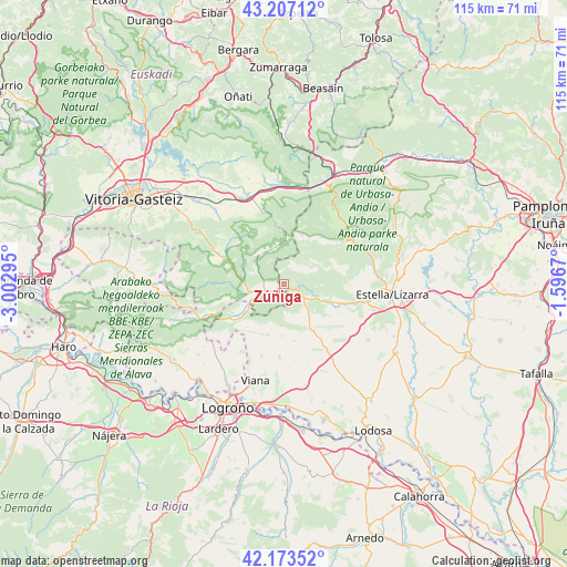
Zúñiga GPS coordinates[2]
42° 41' 32.892" North, 2° 17' 59.352" West
| Map corner | latitude | longitude |
|---|---|---|
| Upper-left | 43.20712°, | -3.00295° |
| Center: | 42.69247°, | -2.29982° |
| Lower-right: | 42.17352°, | -1.5967° |
| Map W x H: | 114.9×114.9 km | = 71.4×71.4mi |
| max Lat: | 43.74134° ⇑8.6% North |
| Zúñiga: | 42.69247° |
| min Lat: | ⇓91.4% South 27.64134° |
| min Long | Zúñiga | max Long |
| -18.00367° | -2.29982° | 4.2899° |
| W 63.5%⇐ | ⇒36.5% E |
Elevation
Elevation of Zúñiga is 568 m = 1864 ft, and this is 30 m = 98 ft below average elevation for this country.
| Max E: |
1682 m = 5518 ft | 56.9% |
| Avg. | 598 m = 1962 ft | |
| Zúñiga | 568 m = 1864 ft | |
Min E: |
0 m = 0 ft | 43.1% |
See also: Spain elevation on elevation.city.
Geographical zone
Zúñiga is located in North temperate zone (between Tropic of Cancer and the Arctic Circle). Distance of this Northern Tropic circle is 2141 km =1330.4 mi to South.| Distance of | km | miles | from Zúñiga |
|---|---|---|---|
| North Pole | 5260.1 | 3268.5 | to North |
| Arctic Circle | 2654.2 | 1649.2 | to North |
| Tropic Cancer | 2141 | 1330.4 | to South |
| Equator | 4747 | 2949.6 | to South |


Nearby cities:
15 places around Zúñiga: (largest is in red/bold)
• Aguilar de Codés
11.5 km =7.1 mi,  219°
219°
• Ancín
9.7 km =6 mi,  111°
111°
• Aranarache
11.3 km =7 mi,  30°
30°
• Azuelo
10.2 km =6.3 mi,  203°
203°
• Cabredo
11.5 km =7.1 mi,  232°
232°
• Desojo
11.8 km =7.3 mi,  169°
169°
• Espronceda
10.6 km =6.6 mi,  182°
182°
• Eulate
12.1 km =7.5 mi,  39°
39°
• Genevilla
9.1 km =5.7 mi, 234°
• Larraona
10.3 km =6.4 mi,  19°
19°
• Legaria
11.4 km =7.1 mi,  115°
115°
• Mirafuentes
7.9 km =4.9 mi, 167°
• Nazar
6.4 km =4 mi, 165°
• Piedramillera
10.3 km =6.4 mi,  130°
130°
• Sorlada
11 km =6.8 mi,  141°
141°
Sources, notices
• [Note1] Compared only with cities in Spain existing in our database
• [Src1] Map data: © OpenStreetMap contributors (CC-BY-SA)
• [Src2] Other city data from geonames.org with taken over terms of usage.
• [Src3] Geographical zone / Annual Mean Temperature by Robert A. Rohde @ Wikipedia
