La Pesga geodata
La Pesga (Extremadura) is a populated place; located in Spain in Europe/Madrid (GMT+2) time zone. With population of 1,162 people, there are 2764 cities with bigger population in this country. Compared to other cities in Spain, 65.3% of cities are located further ↑North; 88.2% of cities are located further →East and 66.7% of cities have higher elevation than La Pesga. Note1


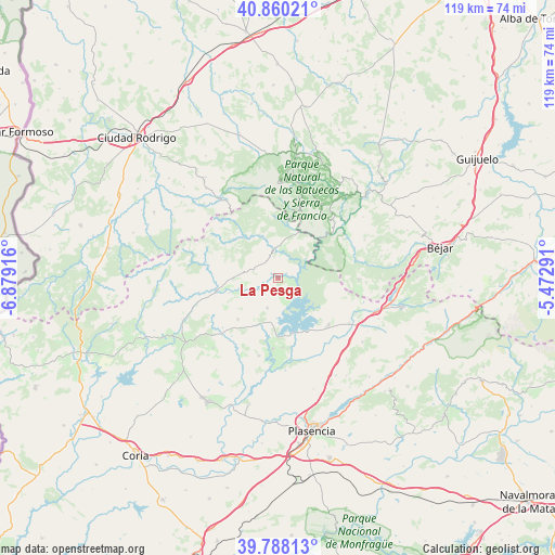
La Pesga GPS coordinates[2]
40° 19' 34.68" North, 6° 10' 33.708" West
| Map corner | latitude | longitude |
|---|---|---|
| Upper-left | 40.86021°, | -6.87916° |
| Center: | 40.3263°, | -6.17603° |
| Lower-right: | 39.78813°, | -5.47291° |
| Map W x H: | 119.2×119.2 km | = 74.1×74.1mi |
| max Lat: | 43.74134° ⇑65.3% North |
| La Pesga: | 40.3263° |
| min Lat: | ⇓34.7% South 27.64134° |
| min Long | La Pesga | max Long |
| -18.00367° | -6.17603° | 4.2899° |
| W 11.8%⇐ | ⇒88.2% E |
Elevation
Elevation of La Pesga is 437 m = 1434 ft, and this is 161 m = 528 ft below average elevation for this country.
| Max E: |
1682 m = 5518 ft | 66.7% |
| Avg. | 598 m = 1962 ft | |
| La Pesga | 437 m = 1434 ft | |
Min E: |
0 m = 0 ft | 33.3% |
See also: Spain elevation on elevation.city.
Geographical zone
La Pesga is located in North temperate zone (between Tropic of Cancer and the Arctic Circle). Distance of this Northern Tropic circle is 1877.9 km =1166.9 mi to South.| Distance of | km | miles | from La Pesga |
|---|---|---|---|
| North Pole | 5523.2 | 3432 | to North |
| Arctic Circle | 2917.3 | 1812.7 | to North |
| Tropic Cancer | 1877.9 | 1166.9 | to South |
| Equator | 4483.9 | 2786.2 | to South |


Nearby cities:
15 places around La Pesga: (largest is in red/bold)
• Ahigal
15.2 km =9.4 mi,  183°
183°
• Caminomorisco
9.6 km =6 mi,  270°
270°
• Casar de Palomero
7.7 km =4.8 mi,  242°
242°
• Casares de las Hurdes
15 km =9.3 mi,  322°
322°
• Cerezo
10.9 km =6.8 mi,  203°
203°
• Guijo de Granadilla
14.8 km =9.2 mi, 175°
• Herguijuela de la Sierra
15.8 km =9.8 mi,  33°
33°
• Ladrillar
16 km =9.9 mi,  345°
345°
• Marchagaz
10.6 km =6.6 mi,  232°
232°
• Nuñomoral
10.8 km =6.7 mi,  326°
326°
• Palomero
12.3 km =7.6 mi,  224°
224°
• Pinofranqueado
13.4 km =8.3 mi,  259°
259°
• Sotoserrano
17.1 km =10.6 mi,  45°
45°
• Valdelageve
16.4 km =10.2 mi,  72°
72°
• Zarza de Granadilla
14.7 km =9.1 mi,  132°
132°
Sources, notices
• [Note1] Compared only with cities in Spain existing in our database
• [Src1] Map data: © OpenStreetMap contributors (CC-BY-SA)
• [Src2] Other city data from geonames.org with taken over terms of usage.
• [Src3] Geographical zone / Annual Mean Temperature by Robert A. Rohde @ Wikipedia
