Pinofranqueado geodata
Pinofranqueado (Extremadura) is a populated place; located in Spain in Europe/Madrid (GMT+2) time zone. With population of 1,649 people, there are 2374 cities with bigger population in this country. Compared to other cities in Spain, 65.7% of cities are located further ↑North; 89.7% of cities are located further →East and 64.5% of cities have higher elevation than Pinofranqueado. Note1
Administrative division(s):
- Level 1: Extremadura
- Level 2: Provincia de Cáceres
- Level 3: Casar de Palomero


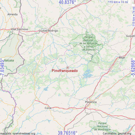
Pinofranqueado GPS coordinates[2]
40° 18' 12.636" North, 6° 19' 54.516" West
| Map corner | latitude | longitude |
|---|---|---|
| Upper-left | 40.8376°, | -7.03493° |
| Center: | 40.30351°, | -6.33181° |
| Lower-right: | 39.76516°, | -5.62868° |
| Map W x H: | 119.2×119.2 km | = 74.1×74.1mi |
| max Lat: | 43.74134° ⇑65.7% North |
| Pinofranqueado: | 40.30351° |
| min Lat: | ⇓34.3% South 27.64134° |
| min Long | Pinofranqueado | max Long |
| -18.00367° | -6.33181° | 4.2899° |
| W 10.3%⇐ | ⇒89.7% E |
Elevation
Elevation of Pinofranqueado is 466 m = 1529 ft, and this is 132 m = 433 ft below average elevation for this country.
| Max E: |
1682 m = 5518 ft | 64.5% |
| Avg. | 598 m = 1962 ft | |
| Pinofranqueado | 466 m = 1529 ft | |
Min E: |
0 m = 0 ft | 35.5% |
See also: Spain elevation on elevation.city.
Geographical zone
Pinofranqueado is located in North temperate zone (between Tropic of Cancer and the Arctic Circle). Distance of this Northern Tropic circle is 1875.4 km =1165.3 mi to South.| Distance of | km | miles | from Pinofranqueado |
|---|---|---|---|
| North Pole | 5525.7 | 3433.5 | to North |
| Arctic Circle | 2919.8 | 1814.3 | to North |
| Tropic Cancer | 1875.4 | 1165.3 | to South |
| Equator | 4481.3 | 2784.5 | to South |


Nearby cities:
15 places around Pinofranqueado: (largest is in red/bold)
• Caminomorisco
4.5 km =2.8 mi,  53°
53°
• Casar de Palomero
6.4 km =4 mi,  98°
98°
• Casares de las Hurdes
15 km =9.3 mi,  15°
15°
• Cerezo
11.5 km =7.1 mi,  130°
130°
• Descargamaría
13.1 km =8.1 mi,  270°
270°
• Hernán-Pérez
15.2 km =9.4 mi,  228°
228°
• La Pesga
13.4 km =8.3 mi,  79°
79°
• Marchagaz
6.3 km =3.9 mi, 129°
• Nuñomoral
13.6 km =8.5 mi,  32°
32°
• Palomero
7.8 km =4.8 mi,  143°
143°
• Robledillo de Gata
12 km =7.5 mi,  280°
280°
• Santa Cruz de Paniagua
12.5 km =7.8 mi,  183°
183°
• Santibáñez el Bajo
16.8 km =10.4 mi,  147°
147°
• Torrecilla de los Ángeles
9.5 km =5.9 mi, 229°
• Villanueva de la Sierra
13 km =8.1 mi,  209°
209°
Sources, notices
• [Note1] Compared only with cities in Spain existing in our database
• [Src1] Map data: © OpenStreetMap contributors (CC-BY-SA)
• [Src2] Other city data from geonames.org with taken over terms of usage.
• [Src3] Geographical zone / Annual Mean Temperature by Robert A. Rohde @ Wikipedia
