Palomero geodata
Palomero (Extremadura) is a seat of a third-order administrative division; located in Spain in Europe/Madrid (GMT+2) time zone. With population of 503 people, there are 3875 cities with bigger population in this country. Compared to other cities in Spain, 66.5% of cities are located further ↑North; 89.3% of cities are located further →East and 65.5% of cities have higher elevation than Palomero. Note1


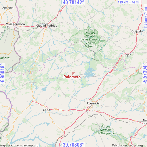
Palomero GPS coordinates[2]
40° 14' 48.768" North, 6° 16' 37.416" West
| Map corner | latitude | longitude |
|---|---|---|
| Upper-left | 40.78142°, | -6.98019° |
| Center: | 40.24688°, | -6.27706° |
| Lower-right: | 39.70808°, | -5.57394° |
| Map W x H: | 119.3×119.3 km | = 74.1×74.1mi |
| max Lat: | 43.74134° ⇑66.5% North |
| Palomero: | 40.24688° |
| min Lat: | ⇓33.5% South 27.64134° |
| min Long | Palomero | max Long |
| -18.00367° | -6.27706° | 4.2899° |
| W 10.7%⇐ | ⇒89.3% E |
Elevation
Elevation of Palomero is 453 m = 1486 ft, and this is 145 m = 476 ft below average elevation for this country.
| Max E: |
1682 m = 5518 ft | 65.5% |
| Avg. | 598 m = 1962 ft | |
| Palomero | 453 m = 1486 ft | |
Min E: |
0 m = 0 ft | 34.5% |
See also: Spain elevation on elevation.city.
Geographical zone
Palomero is located in North temperate zone (between Tropic of Cancer and the Arctic Circle). Distance of this Northern Tropic circle is 1869.1 km =1161.4 mi to South.| Distance of | km | miles | from Palomero |
|---|---|---|---|
| North Pole | 5532 | 3437.4 | to North |
| Arctic Circle | 2926.1 | 1818.2 | to North |
| Tropic Cancer | 1869.1 | 1161.4 | to South |
| Equator | 4475 | 2780.6 | to South |


Nearby cities:
15 places around Palomero: (largest is in red/bold)
• Aceituna
11.8 km =7.3 mi,  203°
203°
• Ahigal
9.9 km =6.2 mi,  130°
130°
• Caminomorisco
9 km =5.6 mi,  353°
353°
• Casar de Palomero
5.6 km =3.5 mi,  17°
17°
• Cerezo
4.3 km =2.7 mi,  104°
104°
• Guijo de Granadilla
11.3 km =7 mi,  121°
121°
• Hernán-Pérez
16.4 km =10.2 mi,  256°
256°
• La Pesga
12.3 km =7.6 mi,  44°
44°
• Marchagaz
2.3 km =1.4 mi,  4°
4°
• Pinofranqueado
7.8 km =4.8 mi,  323°
323°
• Pozuelo de Zarzón
16 km =9.9 mi,  226°
226°
• Santa Cruz de Paniagua
8.1 km =5 mi,  221°
221°
• Santibáñez el Bajo
9 km =5.6 mi,  150°
150°
• Torrecilla de los Ángeles
11.8 km =7.3 mi,  270°
270°
• Villanueva de la Sierra
12.1 km =7.5 mi,  245°
245°
Sources, notices
• [Note1] Compared only with cities in Spain existing in our database
• [Src1] Map data: © OpenStreetMap contributors (CC-BY-SA)
• [Src2] Other city data from geonames.org with taken over terms of usage.
• [Src3] Geographical zone / Annual Mean Temperature by Robert A. Rohde @ Wikipedia
