Guijo de Granadilla geodata
Guijo de Granadilla (Extremadura) is a seat of a third-order administrative division; located in Spain in Europe/Madrid (GMT+2) time zone. With population of 674 people, there are 3451 cities with bigger population in this country. Compared to other cities in Spain, 67.3% of cities are located further ↑North; 88.1% of cities are located further →East and 69.5% of cities have higher elevation than Guijo de Granadilla. Note1
Administrative division(s):
- Level 1: Extremadura
- Level 2: Provincia de Cáceres
- Level 3: Guijo de Granadilla


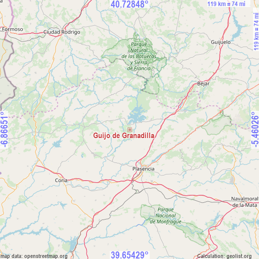
Guijo de Granadilla GPS coordinates[2]
40° 11' 36.636" North, 6° 9' 48.204" West
| Map corner | latitude | longitude |
|---|---|---|
| Upper-left | 40.72848°, | -6.86651° |
| Center: | 40.19351°, | -6.16339° |
| Lower-right: | 39.65429°, | -5.46026° |
| Map W x H: | 119.4×119.4 km | = 74.2×74.2mi |
| max Lat: | 43.74134° ⇑67.3% North |
| Guijo de Granadilla: | 40.19351° |
| min Lat: | ⇓32.7% South 27.64134° |
| min Long | Guijo de Granad | max Long |
| -18.00367° | -6.16339° | 4.2899° |
| W 11.9%⇐ | ⇒88.1% E |
Elevation
Elevation of Guijo de Granadilla is 392 m = 1286 ft, and this is 206 m = 676 ft below average elevation for this country.
| Max E: |
1682 m = 5518 ft | 69.5% |
| Avg. | 598 m = 1962 ft | |
| Guijo de Granadilla | 392 m = 1286 ft | |
Min E: |
0 m = 0 ft | 30.5% |
See also: Spain elevation on elevation.city.
Geographical zone
Guijo de Granadilla is located in North temperate zone (between Tropic of Cancer and the Arctic Circle). Distance of this Northern Tropic circle is 1863.2 km =1157.7 mi to South.| Distance of | km | miles | from Guijo de Granadilla |
|---|---|---|---|
| North Pole | 5538 | 3441.2 | to North |
| Arctic Circle | 2932.1 | 1821.9 | to North |
| Tropic Cancer | 1863.2 | 1157.7 | to South |
| Equator | 4469.1 | 2777 | to South |


Nearby cities:
15 places around Guijo de Granadilla: (largest is in red/bold)
• Aceituna
15.2 km =9.4 mi,  251°
251°
• Ahigal
2.1 km =1.3 mi,  258°
258°
• Cabezabellosa
15.1 km =9.4 mi,  114°
114°
• Casar de Palomero
13.8 km =8.6 mi,  324°
324°
• Cerezo
7.3 km =4.5 mi,  311°
311°
• Jarilla
13.9 km =8.6 mi,  100°
100°
• La Pesga
14.8 km =9.2 mi,  355°
355°
• Marchagaz
12.6 km =7.8 mi, 311°
• Oliva de Plasencia
11.1 km =6.9 mi,  144°
144°
• Palomero
11.3 km =7 mi,  301°
301°
• Santa Cruz de Paniagua
15 km =9.3 mi,  269°
269°
• Santibáñez el Bajo
5.5 km =3.4 mi, 249°
• Valdeobispo
14.2 km =8.8 mi,  210°
210°
• Villar de Plasencia
13.1 km =8.1 mi,  118°
118°
• Zarza de Granadilla
10.9 km =6.8 mi,  63°
63°
Sources, notices
• [Note1] Compared only with cities in Spain existing in our database
• [Src1] Map data: © OpenStreetMap contributors (CC-BY-SA)
• [Src2] Other city data from geonames.org with taken over terms of usage.
• [Src3] Geographical zone / Annual Mean Temperature by Robert A. Rohde @ Wikipedia
