Portillo geodata
Portillo (Castille and León) is a seat of a third-order administrative division; located in Spain in Europe/Madrid (GMT+2) time zone. With population of 2,620 people, there are 1851 cities with bigger population in this country. Compared to other cities in Spain, 60.3% of cities are located further ↓South; 67.3% of cities are located further →East and 74.9% of cities have lower elevation than Portillo. Note1
Administrative division(s):
- Level 1: Castille and León
- Level 2: Provincia de Valladolid
- Level 3: Portillo


Portillo GPS coordinates[2]
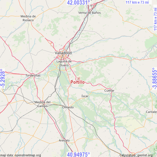
41° 28' 43.212" North, 4° 35' 22.812" West
| Map corner | latitude | longitude |
|---|---|---|
| Upper-left | 42.00331°, | -5.2928° |
| Center: | 41.47867°, | -4.58967° |
| Lower-right: | 40.94975°, | -3.88655° |
| Map W x H: | 117.1×117.1 km | = 72.8×72.8mi |
| max Lat: | 43.74134° ⇑39.7% North |
| Portillo: | 41.47867° |
| min Lat: | ⇓60.3% South 27.64134° |
| min Long | Portillo | max Long |
| -18.00367° | -4.58967° | 4.2899° |
| W 32.7%⇐ | ⇒67.3% E |
Elevation
Elevation of Portillo is 850 m = 2789 ft, and this is 252 m = 827 ft above average elevation for this country.
| Max E: |
1682 m = 5518 ft | 25.1% |
| Portillo | 850 m 2789 ft | |
| Avg. | 598 m = 1962 ft | |
Min E: |
0 m = 0 ft | 74.9% |
See also: Spain elevation on elevation.city.
Geographical zone
Portillo is located in North temperate zone (between Tropic of Cancer and the Arctic Circle). Distance of this Northern Tropic circle is 2006.1 km =1246.5 mi to South.| Distance of | km | miles | from Portillo |
|---|---|---|---|
| North Pole | 5395.1 | 3352.4 | to North |
| Arctic Circle | 2789.2 | 1733.1 | to North |
| Tropic Cancer | 2006.1 | 1246.5 | to South |
| Equator | 4612 | 2865.8 | to South |


Nearby cities:
15 places around Portillo: (largest is in red/bold)
• Alcazarén
13.9 km =8.6 mi,  209°
209°
• Aldea de San Miguel
2.9 km =1.8 mi,  227°
227°
• Aldeamayor de San Martín
5.6 km =3.5 mi,  312°
312°
• Boecillo
11.5 km =7.1 mi, 307°
• Camporredondo
7.1 km =4.4 mi,  94°
94°
• Iscar
13.9 km =8.6 mi,  160°
160°
• La Parrilla
7.9 km =4.9 mi,  36°
36°
• La Pedraja de Portillo
4.8 km =3 mi,  260°
260°
• Mata de Cuéllar
13.4 km =8.3 mi,  132°
132°
• Megeces
8.2 km =5.1 mi, 163°
• Mojados
8.1 km =5 mi, 230°
• Montemayor de Pililla
11.5 km =7.1 mi,  73°
73°
• San Miguel del Arroyo
11.5 km =7.1 mi,  109°
109°
• Traspinedo
14.3 km =8.9 mi, 41°
• Tudela de Duero
11.8 km =7.3 mi,  3°
3°
Sources, notices
• [Note1] Compared only with cities in Spain existing in our database
• [Src1] Map data: © OpenStreetMap contributors (CC-BY-SA)
• [Src2] Other city data from geonames.org with taken over terms of usage.
• [Src3] Geographical zone / Annual Mean Temperature by Robert A. Rohde @ Wikipedia
