La Pedraja de Portillo geodata
La Pedraja de Portillo (Castille and León) is a populated place; located in Spain in Europe/Madrid (GMT+2) time zone. With population of 1,048 people, there are 2885 cities with bigger population in this country. Compared to other cities in Spain, 60.1% of cities are located further ↓South; 68% of cities are located further →East and 56.4% of cities have lower elevation than La Pedraja de Portillo. Note1
Administrative division(s):
- Level 1: Castille and León
- Level 2: Provincia de Valladolid
- Level 3: Aldea de San Miguel
Current local time in La Pedraja de Portillo:
10:47 PM, ThursdayDifference from your time zone: hours


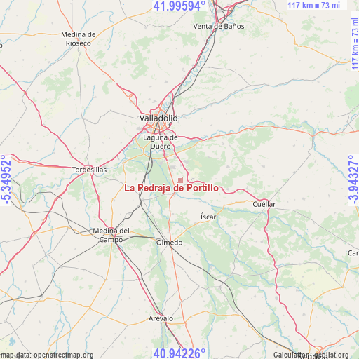
La Pedraja de Portillo GPS coordinates[2]
41° 28' 16.464" North, 4° 38' 47.004" West
| Map corner | latitude | longitude |
|---|---|---|
| Upper-left | 41.99594°, | -5.34952° |
| Center: | 41.47124°, | -4.64639° |
| Lower-right: | 40.94226°, | -3.94327° |
| Map W x H: | 117.2×117.2 km | = 72.8×72.8mi |
| max Lat: | 43.74134° ⇑39.9% North |
| La Pedraja de Portillo: | 41.47124° |
| min Lat: | ⇓60.1% South 27.64134° |
| min Long | La Pedraja de P | max Long |
| -18.00367° | -4.64639° | 4.2899° |
| W 32%⇐ | ⇒68% E |
Elevation
Elevation of La Pedraja de Portillo is 719 m = 2359 ft, and this is 121 m = 397 ft above average elevation for this country.
| Max E: |
1682 m = 5518 ft | 43.6% |
| La Pedraja de Portillo | 719 m 2359 ft | |
| Avg. | 598 m = 1962 ft | |
Min E: |
0 m = 0 ft | 56.4% |
See also: Spain elevation on elevation.city.
Geographical zone
La Pedraja de Portillo is located in North temperate zone (between Tropic of Cancer and the Arctic Circle). Distance of this Northern Tropic circle is 2005.3 km =1246 mi to South.| Distance of | km | miles | from La Pedraja de Portillo |
|---|---|---|---|
| North Pole | 5395.9 | 3352.9 | to North |
| Arctic Circle | 2790 | 1733.6 | to North |
| Tropic Cancer | 2005.3 | 1246 | to South |
| Equator | 4611.2 | 2865.3 | to South |


Nearby cities:
15 places around La Pedraja de Portillo: (largest is in red/bold)
• Alcazarén
11.4 km =7.1 mi,  191°
191°
• Aldea de San Miguel
2.8 km =1.7 mi,  114°
114°
• Aldeamayor de San Martín
4.6 km =2.9 mi,  7°
7°
• Boecillo
8.9 km =5.5 mi,  330°
330°
• Camporredondo
11.8 km =7.3 mi,  88°
88°
• Iscar
15.4 km =9.6 mi,  142°
142°
• La Parrilla
11.9 km =7.4 mi,  52°
52°
• Laguna de Duero
13.8 km =8.6 mi, 332°
• Matapozuelos
13.6 km =8.5 mi,  242°
242°
• Megeces
9.9 km =6.2 mi,  134°
134°
• Mojados
4.6 km =2.9 mi,  199°
199°
• Portillo
4.8 km =3 mi,  80°
80°
• Tudela de Duero
13.7 km =8.5 mi,  23°
23°
• Valdestillas
10.4 km =6.5 mi,  273°
273°
• Viana de Cega
10.9 km =6.8 mi,  306°
306°
Sources, notices
• [Note1] Compared only with cities in Spain existing in our database
• [Src1] Map data: © OpenStreetMap contributors (CC-BY-SA)
• [Src2] Other city data from geonames.org with taken over terms of usage.
• [Src3] Geographical zone / Annual Mean Temperature by Robert A. Rohde @ Wikipedia
