Lagartos geodata
Lagartos (Castille and León) is a seat of a third-order administrative division; located in Spain in Europe/Madrid (GMT+2) time zone. With population of 136 people, there are 5534 cities with bigger population in this country. Compared to other cities in Spain, 85% of cities are located further ↓South; 71.1% of cities are located further →East and 81.9% of cities have lower elevation than Lagartos. Note1
Administrative division(s):
- Level 1: Castille and León
- Level 2: Provincia de Palencia
- Level 3: Lagartos


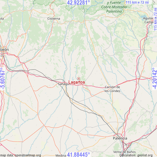
Lagartos GPS coordinates[2]
42° 24' 20.808" North, 4° 54' 16.344" West
| Map corner | latitude | longitude |
|---|---|---|
| Upper-left | 42.92281°, | -5.60767° |
| Center: | 42.40578°, | -4.90454° |
| Lower-right: | 41.88445°, | -4.20142° |
| Map W x H: | 115.5×115.5 km | = 71.8×71.8mi |
| max Lat: | 43.74134° ⇑15% North |
| Lagartos: | 42.40578° |
| min Lat: | ⇓85% South 27.64134° |
| min Long | Lagartos | max Long |
| -18.00367° | -4.90454° | 4.2899° |
| W 28.9%⇐ | ⇒71.1% E |
Elevation
Elevation of Lagartos is 916 m = 3005 ft, and this is 318 m = 1043 ft above average elevation for this country.
| Max E: |
1682 m = 5518 ft | 18.1% |
| Lagartos | 916 m 3005 ft | |
| Avg. | 598 m = 1962 ft | |
Min E: |
0 m = 0 ft | 81.9% |
See also: Spain elevation on elevation.city.
Geographical zone
Lagartos is located in North temperate zone (between Tropic of Cancer and the Arctic Circle). Distance of this Northern Tropic circle is 2109.2 km =1310.6 mi to South.| Distance of | km | miles | from Lagartos |
|---|---|---|---|
| North Pole | 5292 | 3288.3 | to North |
| Arctic Circle | 2686.1 | 1669.1 | to North |
| Tropic Cancer | 2109.2 | 1310.6 | to South |
| Equator | 4715.1 | 2929.8 | to South |


Nearby cities:
15 places around Lagartos: (largest is in red/bold)
• Bustillo de la Vega
14.5 km =9 mi,  67°
67°
• Bustillo del Páramo de Carrión
14.7 km =9.1 mi,  112°
112°
• Calzada del Coto
14.4 km =8.9 mi,  261°
261°
• Cea
10.8 km =6.7 mi,  305°
305°
• Escobar de Campos
11.4 km =7.1 mi,  206°
206°
• Grajal de Campos
13.4 km =8.3 mi,  224°
224°
• Ledigos
6.5 km =4 mi,  150°
150°
• Moratinos
5.3 km =3.3 mi,  201°
201°
• Población de Arroyo
8.1 km =5 mi,  161°
161°
• Sahagún
11 km =6.8 mi,  249°
249°
• Santervás de la Vega
14.1 km =8.8 mi,  37°
37°
• Villalcón
13.2 km =8.2 mi, 162°
• Villamol
12.1 km =7.5 mi,  281°
281°
• Villarrabé
10 km =6.2 mi,  80°
80°
• Villazanzo de Valderaduey
15.3 km =9.5 mi,  341°
341°
Sources, notices
• [Note1] Compared only with cities in Spain existing in our database
• [Src1] Map data: © OpenStreetMap contributors (CC-BY-SA)
• [Src2] Other city data from geonames.org with taken over terms of usage.
• [Src3] Geographical zone / Annual Mean Temperature by Robert A. Rohde @ Wikipedia
