Ledigos geodata
Ledigos (Castille and León) is a seat of a third-order administrative division; located in Spain in Europe/Madrid (GMT+2) time zone. With population of 92 people, there are 6032 cities with bigger population in this country. Compared to other cities in Spain, 83.4% of cities are located further ↓South; 70.7% of cities are located further →East and 77.8% of cities have lower elevation than Ledigos. Note1
Administrative division(s):
- Level 1: Castille and León
- Level 2: Provincia de Palencia
- Level 3: Ledigos


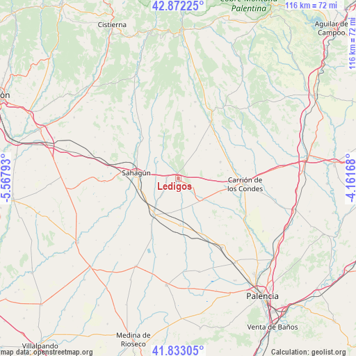
Ledigos GPS coordinates[2]
42° 21' 17.28" North, 4° 51' 53.28" West
| Map corner | latitude | longitude |
|---|---|---|
| Upper-left | 42.87225°, | -5.56793° |
| Center: | 42.3548°, | -4.8648° |
| Lower-right: | 41.83305°, | -4.16168° |
| Map W x H: | 115.5×115.5 km | = 71.8×71.8mi |
| max Lat: | 43.74134° ⇑16.6% North |
| Ledigos: | 42.3548° |
| min Lat: | ⇓83.4% South 27.64134° |
| min Long | Ledigos | max Long |
| -18.00367° | -4.8648° | 4.2899° |
| W 29.3%⇐ | ⇒70.7% E |
Elevation
Elevation of Ledigos is 877 m = 2877 ft, and this is 279 m = 915 ft above average elevation for this country.
| Max E: |
1682 m = 5518 ft | 22.2% |
| Ledigos | 877 m 2877 ft | |
| Avg. | 598 m = 1962 ft | |
Min E: |
0 m = 0 ft | 77.8% |
See also: Spain elevation on elevation.city.
Geographical zone
Ledigos is located in North temperate zone (between Tropic of Cancer and the Arctic Circle). Distance of this Northern Tropic circle is 2103.5 km =1307.1 mi to South.| Distance of | km | miles | from Ledigos |
|---|---|---|---|
| North Pole | 5297.6 | 3291.8 | to North |
| Arctic Circle | 2691.8 | 1672.6 | to North |
| Tropic Cancer | 2103.5 | 1307.1 | to South |
| Equator | 4709.4 | 2926.3 | to South |


Nearby cities:
15 places around Ledigos: (largest is in red/bold)
• Bustillo del Páramo de Carrión
10.3 km =6.4 mi,  89°
89°
• Cervatos de la Cueza
10.6 km =6.6 mi,  132°
132°
• Escobar de Campos
9.5 km =5.9 mi,  240°
240°
• Grajal de Campos
13.3 km =8.3 mi,  253°
253°
• Lagartos
6.5 km =4 mi,  330°
330°
• Moratinos
5.3 km =3.3 mi,  278°
278°
• Población de Arroyo
2.1 km =1.3 mi,  200°
200°
• Pozo de Urama
11.4 km =7.1 mi,  192°
192°
• Riberos de la Cueza
14.3 km =8.9 mi, 126°
• Sahagún
13.6 km =8.5 mi, 277°
• San Román de la Cuba
10.3 km =6.4 mi,  176°
176°
• Villada
14.3 km =8.9 mi,  216°
216°
• Villalcón
6.9 km =4.3 mi,  173°
173°
• Villamoronta
14.7 km =9.1 mi,  68°
68°
• Villarrabé
9.9 km =6.2 mi,  41°
41°
Sources, notices
• [Note1] Compared only with cities in Spain existing in our database
• [Src1] Map data: © OpenStreetMap contributors (CC-BY-SA)
• [Src2] Other city data from geonames.org with taken over terms of usage.
• [Src3] Geographical zone / Annual Mean Temperature by Robert A. Rohde @ Wikipedia
